Nova Olímpia geodata
Nova Olímpia (Mato Grosso) is a populated place; located in Brazil in America/Cuiaba (GMT-4) time zone. With population of 19,274 people, there are 972 cities with bigger population in this country. Compared to other cities in Brazil, 56.5% of cities are located further ↓South; 96.5% of cities are located further →East and 63.2% of cities have higher elevation than Nova Olímpia. Note1


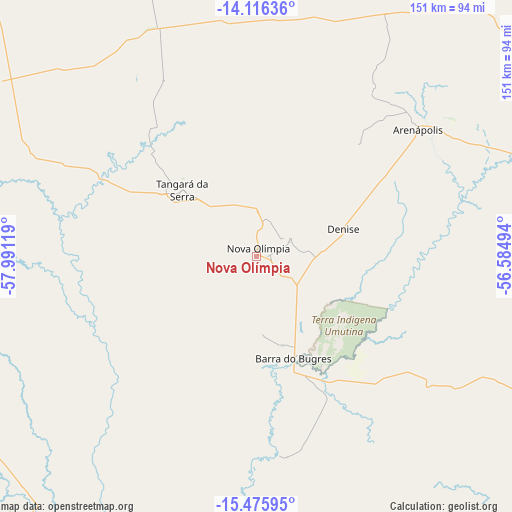
Nova Olímpia GPS coordinates[2]
14° 47' 49.992" South, 57° 17' 17.016" West
| Map corner | latitude | longitude |
|---|---|---|
| Upper-left | -14.11636°, | -57.99119° |
| Center: | -14.79722°, | -57.28806° |
| Lower-right: | -15.47595°, | -56.58494° |
| Map W x H: | 151.2×151.2 km | = 94×94mi |
| max Lat: | 2.81972° ⇑43.5% North |
| Nova Olímpia: | -14.79722° |
| min Lat: | ⇓56.5% South -33.69111° |
| min Long | Nova Olímpia | max Long |
| -72.89583° | -57.28806° | -32.41083° |
| W 3.5%⇐ | ⇒96.5% E |
Elevation
Elevation of Nova Olímpia is 183 m = 600 ft, and this is 197.9 m = 649 ft below average elevation for this country.
| Max E: |
1603 m = 5259 ft | 63.2% |
| Avg. | 380.9 m = 1250 ft | |
| Nova Olímpia | 183 m = 600 ft | |
Min E: |
0 m = 0 ft | 36.8% |
See also: Brazil elevation on elevation.city.
Geographical zone
Nova Olímpia is located in South Torrid zone (between Equator and Tropic of Capricorn). Distance of this Southern Tropic circle is 960.6 km =596.9 mi to South.| Distance of | km | miles | from Nova Olímpia |
|---|---|---|---|
| Equator | 1645.3 | 1022.3 | to North |
| Tropic Capricorn | 960.6 | 596.9 | to South |
| Antarctic Circle | 5755.9 | 3576.5 | to South |
| South Pole | 8361.8 | 5195.8 | to South |


Nearby cities:
15 places around Nova Olímpia: (largest is in red/bold)
• Arenápolis
61.2 km =38 mi,  50°
50°
• Barra do Bugres
32.7 km =20.3 mi,  159°
159°
• Barão de Melgaço
210.1 km =130.6 mi,  137°
137°
• Chapada dos Guimarães
180.8 km =112.3 mi,  114°
114°
• Cuiabá
155.7 km =96.7 mi,  124°
124°
• Diamantino
100.4 km =62.4 mi,  64°
64°
• Lucas
224.1 km =139.2 mi, 139°
• Lucas do Rio Verde
242 km =150.4 mi,  37°
37°
• Nobres
103.6 km =64.4 mi,  85°
85°
• Nortelândia
64.6 km =40.1 mi, 53°
• Poconé
177.2 km =110.1 mi, 156°
• Pontes e Lacerda
225 km =139.8 mi,  257°
257°
• Rosário Oeste
92.6 km =57.5 mi, 92°
• Santo Antônio do Leverger
176 km =109.4 mi,  132°
132°
• Várzea Grande
155.9 km =96.9 mi, 127°
Sources, notices
• [Note1] Compared only with cities in Brazil existing in our database
• [Src1] Map data: © OpenStreetMap contributors (CC-BY-SA)
• [Src2] Other city data from geonames.org with taken over terms of usage.
• [Src3] Geographical zone / Annual Mean Temperature by Robert A. Rohde @ Wikipedia
