Ilha Grande geodata
Ilha Grande (Rio de Janeiro) is a populated place; located in Brazil in America/Sao_Paulo (GMT-3) time zone. With population of 3,000 people, there are 1990 cities with bigger population in this country. Compared to other cities in Brazil, 80% of cities are located further ↑North; 54.6% of cities are located further ←West and 93.6% of cities have lower elevation than Ilha Grande. Note1


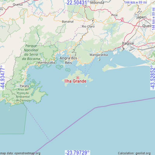
Ilha Grande GPS coordinates[2]
23° 9' 8.496" South, 44° 13' 53.904" West
| Map corner | latitude | longitude |
|---|---|---|
| Upper-left | -22.50431°, | -44.93477° |
| Center: | -23.15236°, | -44.23164° |
| Lower-right: | -23.79729°, | -43.52852° |
| Map W x H: | 143.8×143.8 km | = 89.4×89.4mi |
| max Lat: | 2.81972° ⇑80% North |
| Ilha Grande: | -23.15236° |
| min Lat: | ⇓20% South -33.69111° |
| min Long | Ilha Grande | max Long |
| -72.89583° | -44.23164° | -32.41083° |
| W 54.6%⇐ | ⇒45.4% E |
Elevation
Elevation of Ilha Grande is 876 m = 2874 ft, and this is 495.1 m = 1624 ft above average elevation for this country.
| Max E: |
1603 m = 5259 ft | 6.4% |
| Ilha Grande | 876 m 2874 ft | |
| Avg. | 380.9 m = 1250 ft | |
Min E: |
0 m = 0 ft | 93.6% |
See also: Brazil elevation on elevation.city.
Geographical zone
Ilha Grande is located in South Torrid zone (between Equator and Tropic of Capricorn). Distance of this Southern Tropic circle is 31.6 km =19.6 mi to South.| Distance of | km | miles | from Ilha Grande |
|---|---|---|---|
| Equator | 2574.3 | 1599.6 | to North |
| Tropic Capricorn | 31.6 | 19.6 | to South |
| Antarctic Circle | 4826.9 | 2999.3 | to South |
| South Pole | 7432.8 | 4618.5 | to South |


Nearby cities:
15 places around Ilha Grande: (largest is in red/bold)
• Angra dos Reis
18.5 km =11.5 mi,  331°
331°
• Barra Mansa
67.9 km =42.2 mi,  5°
5°
• Cunha
75 km =46.6 mi,  276°
276°
• Itaguaí
57.4 km =35.7 mi,  54°
54°
• Itatiaia
80.5 km =50 mi,  335°
335°
• Mangaratiba
29 km =18 mi,  42°
42°
• Paracambi
80.8 km =50.2 mi, 41°
• Paraty
49.7 km =30.9 mi,  261°
261°
• Pinheiral
75 km =46.6 mi,  18°
18°
• Piraí
67.5 km =41.9 mi,  30°
30°
• Porto Real
81.7 km =50.8 mi,  355°
355°
• Resende
79.1 km =49.2 mi, 343°
• Rio Claro
48.7 km =30.3 mi, 11°
• Seropédica
70.3 km =43.7 mi, 49°
• Volta Redonda
71.2 km =44.2 mi, 10°
Sources, notices
• [Note1] Compared only with cities in Brazil existing in our database
• [Src1] Map data: © OpenStreetMap contributors (CC-BY-SA)
• [Src2] Other city data from geonames.org with taken over terms of usage.
• [Src3] Geographical zone / Annual Mean Temperature by Robert A. Rohde @ Wikipedia
