Cunha geodata
Cunha (São Paulo) is a populated place; located in Brazil in America/Sao_Paulo (GMT-3) time zone. With population of 11,895 people, there are 1490 cities with bigger population in this country. Compared to other cities in Brazil, 79.4% of cities are located further ↑North; 51.5% of cities are located further ←West and 97.4% of cities have lower elevation than Cunha. Note1


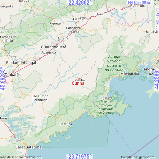
Cunha GPS coordinates[2]
23° 4' 27.984" South, 44° 57' 34.992" West
| Map corner | latitude | longitude |
|---|---|---|
| Upper-left | -22.42602°, | -45.66285° |
| Center: | -23.07444°, | -44.95972° |
| Lower-right: | -23.71975°, | -44.2566° |
| Map W x H: | 143.8×143.9 km | = 89.4×89.4mi |
| max Lat: | 2.81972° ⇑79.4% North |
| Cunha: | -23.07444° |
| min Lat: | ⇓20.6% South -33.69111° |
| min Long | Cunha | max Long |
| -72.89583° | -44.95972° | -32.41083° |
| W 51.5%⇐ | ⇒48.5% E |
Elevation
Elevation of Cunha is 953 m = 3127 ft, and this is 572.1 m = 1877 ft above average elevation for this country.
| Max E: |
1603 m = 5259 ft | 2.6% |
| Cunha | 953 m 3127 ft | |
| Avg. | 380.9 m = 1250 ft | |
Min E: |
0 m = 0 ft | 97.4% |
See also: Brazil elevation on elevation.city.
Geographical zone
Cunha is located in South Torrid zone (between Equator and Tropic of Capricorn). Distance of this Southern Tropic circle is 40.3 km =25 mi to South.| Distance of | km | miles | from Cunha |
|---|---|---|---|
| Equator | 2565.6 | 1594.2 | to North |
| Tropic Capricorn | 40.3 | 25 | to South |
| Antarctic Circle | 4835.5 | 3004.6 | to South |
| South Pole | 7441.4 | 4623.9 | to South |


Nearby cities:
15 places around Cunha: (largest is in red/bold)
• Angra dos Reis
66.1 km =41.1 mi,  83°
83°
• Aparecida
37.5 km =23.3 mi,  312°
312°
• Campos do Jordão
74.7 km =46.4 mi,  299°
299°
• Cruzeiro
55.7 km =34.6 mi,  358°
358°
• Guaratinguetá
37.3 km =23.2 mi,  320°
320°
• Ilha Grande
75 km =46.6 mi,  96°
96°
• Itatiaia
76.1 km =47.3 mi,  32°
32°
• Lorena
41.8 km =26 mi,  336°
336°
• Paraty
29.8 km =18.5 mi,  122°
122°
• Passa Quatro
76.1 km =47.3 mi, 359°
• Pindamonhangaba
54 km =33.6 mi,  288°
288°
• Piquete
55.8 km =34.7 mi, 336°
• Taubaté
61.2 km =38 mi,  275°
275°
• Tremembé
61.7 km =38.3 mi, 282°
• Ubatuba
41.6 km =25.8 mi,  195°
195°
Sources, notices
• [Note1] Compared only with cities in Brazil existing in our database
• [Src1] Map data: © OpenStreetMap contributors (CC-BY-SA)
• [Src2] Other city data from geonames.org with taken over terms of usage.
• [Src3] Geographical zone / Annual Mean Temperature by Robert A. Rohde @ Wikipedia
