Paraty geodata
Paraty (Rio de Janeiro) is a populated place; located in Brazil in America/Sao_Paulo (GMT-3) time zone. With population of 15,118 people, there are 1206 cities with bigger population in this country. Compared to other cities in Brazil, 80.6% of cities are located further ↑North; 52.8% of cities are located further ←West and 96.1% of cities have higher elevation than Paraty. Note1


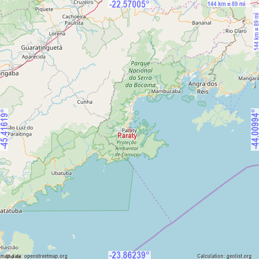
Paraty GPS coordinates[2]
23° 13' 4.008" South, 44° 42' 47.016" West
| Map corner | latitude | longitude |
|---|---|---|
| Upper-left | -22.57005°, | -45.41619° |
| Center: | -23.21778°, | -44.71306° |
| Lower-right: | -23.86239°, | -44.00994° |
| Map W x H: | 143.7×143.7 km | = 89.3×89.3mi |
| max Lat: | 2.81972° ⇑80.6% North |
| Paraty: | -23.21778° |
| min Lat: | ⇓19.4% South -33.69111° |
| min Long | Paraty | max Long |
| -72.89583° | -44.71306° | -32.41083° |
| W 52.8%⇐ | ⇒47.2% E |
Elevation
Elevation of Paraty is 8 m = 26 ft, and this is 372.9 m = 1223 ft below average elevation for this country.
| Max E: |
1603 m = 5259 ft | 96.1% |
| Avg. | 380.9 m = 1250 ft | |
| Paraty | 8 m = 26 ft | |
Min E: |
0 m = 0 ft | 3.9% |
See also: Brazil elevation on elevation.city.
Geographical zone
Paraty is located in South Torrid zone (between Equator and Tropic of Capricorn). Distance of this Southern Tropic circle is 24.3 km =15.1 mi to South.| Distance of | km | miles | from Paraty |
|---|---|---|---|
| Equator | 2581.6 | 1604.1 | to North |
| Tropic Capricorn | 24.3 | 15.1 | to South |
| Antarctic Circle | 4819.6 | 2994.8 | to South |
| South Pole | 7425.5 | 4614 | to South |


Nearby cities:
15 places around Paraty: (largest is in red/bold)
• Angra dos Reis
46.7 km =29 mi,  59°
59°
• Aparecida
67 km =41.6 mi,  307°
307°
• Caraguatatuba
84.3 km =52.4 mi,  237°
237°
• Cruzeiro
76.4 km =47.5 mi,  339°
339°
• Cunha
29.8 km =18.5 mi,  302°
302°
• Guaratinguetá
66.3 km =41.2 mi, 312°
• Ilha Grande
49.7 km =30.9 mi,  81°
81°
• Itatiaia
81.7 km =50.8 mi,  10°
10°
• Lorena
68.6 km =42.6 mi,  322°
322°
• Mangaratiba
74.5 km =46.3 mi,  67°
67°
• Pindamonhangaba
83.3 km =51.8 mi,  293°
293°
• Piquete
82.2 km =51.1 mi, 324°
• Resende
87.6 km =54.4 mi,  18°
18°
• Rio Claro
80.8 km =50.2 mi,  47°
47°
• Ubatuba
43.7 km =27.2 mi, 236°
Sources, notices
• [Note1] Compared only with cities in Brazil existing in our database
• [Src1] Map data: © OpenStreetMap contributors (CC-BY-SA)
• [Src2] Other city data from geonames.org with taken over terms of usage.
• [Src3] Geographical zone / Annual Mean Temperature by Robert A. Rohde @ Wikipedia
