Ratholo geodata
Ratholo (Central) is a populated place; located in Botswana in Africa/Gaborone (GMT+2) time zone. With population of 2,377 people, there are 48 cities with bigger population in this country. Compared to other cities in Botswana, 58.1% of cities are located further ↓South; 91.4% of cities are located further ←West and 79% of cities have higher elevation than Ratholo. Note1


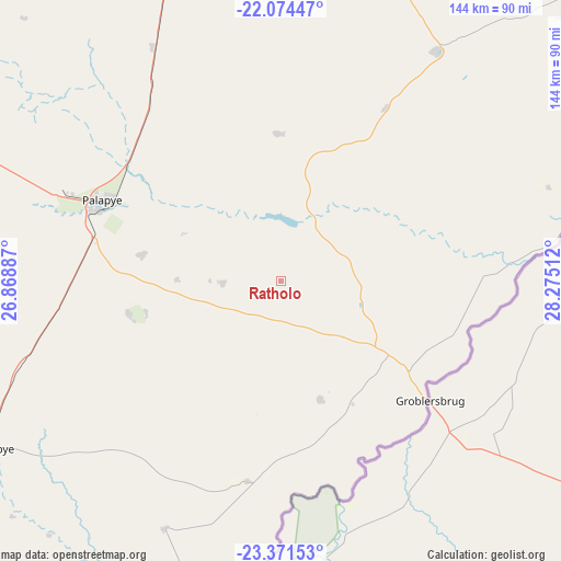
Ratholo GPS coordinates[2]
22° 43' 28.344" South, 27° 34' 19.164" East
| Map corner | latitude | longitude |
|---|---|---|
| Upper-left | -22.07447°, | 26.86887° |
| Center: | -22.72454°, | 27.57199° |
| Lower-right: | -23.37153°, | 28.27512° |
| Map W x H: | 144.2×144.2 km | = 89.6×89.6mi |
| max Lat: | -17.80165° ⇑41.9% North |
| Ratholo: | -22.72454° |
| min Lat: | ⇓58.1% South -26.9° |
| min Long | Ratholo | max Long |
| 20.06667° | 27.57199° | 28.74946° |
| W 91.4%⇐ | ⇒8.6% E |
Elevation
Elevation of Ratholo is 924 m = 3031 ft, and this is 91 m = 299 ft below average elevation for this country.
| Max E: |
1406 m = 4613 ft | 79% |
| Avg. | 1015 m = 3330 ft | |
| Ratholo | 924 m = 3031 ft | |
Min E: |
676 m = 2218 ft | 21% |
See also: Botswana elevation on elevation.city.
Geographical zone
Ratholo is located in South Torrid zone (between Equator and Tropic of Capricorn). Distance of this Southern Tropic circle is 79.2 km =49.2 mi to South.| Distance of | km | miles | from Ratholo |
|---|---|---|---|
| Equator | 2526.7 | 1570 | to North |
| Tropic Capricorn | 79.2 | 49.2 | to South |
| Antarctic Circle | 4874.4 | 3028.8 | to South |
| South Pole | 7480.3 | 4648 | to South |


Nearby cities:
15 places around Ratholo: (largest is in red/bold)
• Letsheng
36.3 km =22.6 mi,  280°
280°
• Maapi
23.1 km =14.4 mi,  260°
260°
• Machaneng
52 km =32.3 mi,  189°
189°
• Makobeng
31.8 km =19.8 mi,  162°
162°
• Malaka
27.7 km =17.2 mi,  295°
295°
• Mathakola
26.8 km =16.7 mi,  270°
270°
• Maunatlala
15.4 km =9.6 mi,  22°
22°
• Mogapi
52.2 km =32.4 mi,  31°
31°
• Mogapinyana
39.9 km =24.8 mi,  4°
4°
• Moremi
21 km =13 mi,  323°
323°
• Palapye
50 km =31.1 mi,  293°
293°
• Pilikwe
39.7 km =24.7 mi, 257°
• Ramokgonami
21.7 km =13.5 mi,  224°
224°
• Shakgwe
60.5 km =37.6 mi,  225°
225°
• Tamasane
38.3 km =23.8 mi,  332°
332°
Sources, notices
• [Note1] Compared only with cities in Botswana existing in our database
• [Src1] Map data: © OpenStreetMap contributors (CC-BY-SA)
• [Src2] Other city data from geonames.org with taken over terms of usage.
• [Src3] Geographical zone / Annual Mean Temperature by Robert A. Rohde @ Wikipedia
