Saint-Honoré geodata
Saint-Honoré (Quebec) is a populated place; located in Canada in America/Toronto (GMT-4) time zone. With population of 2,265 people, there are 706 cities with bigger population in this country. Compared to other cities in Canada, 58.2% of cities are located further ↓South; 80.6% of cities are located further ←West and 54.4% of cities have higher elevation than Saint-Honoré. Note1


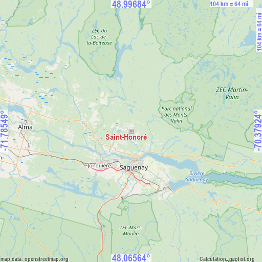
Saint-Honoré GPS coordinates[2]
48° 32' 0.168" North, 71° 4' 56.496" West
| Map corner | latitude | longitude |
|---|---|---|
| Upper-left | 48.99684°, | -71.78549° |
| Center: | 48.53338°, | -71.08236° |
| Lower-right: | 48.06564°, | -70.37924° |
| Map W x H: | 103.5×103.5 km | = 64.3×64.3mi |
| max Lat: | 73.03752° ⇑41.8% North |
| Saint-Honoré: | 48.53338° |
| min Lat: | ⇓58.2% South 42.05009° |
| min Long | Saint-Honoré | max Long |
| -139.43328° | -71.08236° | -52.70931° |
| W 80.6%⇐ | ⇒19.4% E |
Elevation
Elevation of Saint-Honoré is 144 m = 472 ft, and this is 110.4 m = 362 ft below average elevation for this country.
| Max E: |
1518 m = 4980 ft | 54.4% |
| Avg. | 254.4 m = 835 ft | |
| Saint-Honoré | 144 m = 472 ft | |
Min E: |
-2 m = -7 ft | 45.6% |
See also: Canada elevation on elevation.city.
Geographical zone
Saint-Honoré is located in North temperate zone (between Tropic of Cancer and the Arctic Circle). Distance of this North polar circle is 2004.8 km =1245.7 mi to North.| Distance of | km | miles | from Saint-Honoré |
|---|---|---|---|
| North Pole | 4610.7 | 2865 | to North |
| Arctic Circle | 2004.8 | 1245.7 | to North |
| Tropic Cancer | 2790.5 | 1733.9 | to South |
| Equator | 5396.4 | 3353.2 | to South |


Nearby cities:
15 places around Saint-Honoré: (largest is in red/bold)
• Alma
41.8 km =26 mi,  272°
272°
• Chambord
73.3 km =45.5 mi,  261°
261°
• Jonquière
17.9 km =11.1 mi,  223°
223°
• L'Ascension-de-Notre-Seigneur
46 km =28.6 mi,  291°
291°
• Metabetchouan-Lac-a-la-Croix
53.2 km =33.1 mi, 255°
• Métabetchouan
71.3 km =44.3 mi,  254°
254°
• Pointe-du-Lac
51.7 km =32.1 mi, 265°
• Pont Rouge
83.1 km =51.6 mi,  297°
297°
• Roberval
84.7 km =52.6 mi, 268°
• Saguenay
13 km =8.1 mi,  174°
174°
• Saint-Ambroise
18.5 km =11.5 mi,  275°
275°
• Saint-Bruno
42.4 km =26.3 mi, 259°
• Saint-Charles-de-Bourget
21.2 km =13.2 mi, 280°
• Saint-Gédéon
50.5 km =31.4 mi, 265°
• Saint-Nazaire
35.2 km =21.9 mi, 280°
Sources, notices
• [Note1] Compared only with cities in Canada existing in our database
• [Src1] Map data: © OpenStreetMap contributors (CC-BY-SA)
• [Src2] Other city data from geonames.org with taken over terms of usage.
• [Src3] Geographical zone / Annual Mean Temperature by Robert A. Rohde @ Wikipedia
