Saint-Charles-de-Bourget geodata
Saint-Charles-de-Bourget (Quebec) is a populated place; located in Canada in America/Toronto (GMT-4) time zone. With population of 690 people, there are 1121 cities with bigger population in this country. Compared to other cities in Canada, 58.6% of cities are located further ↓South; 79.6% of cities are located further ←West and 56% of cities have higher elevation than Saint-Charles-de-Bourget. Note1
Administrative division(s):
- Level 1: Quebec
- Level 2: Saguenay/Lac-Saint-Jean
- Level 3: Saint-Ambroise
Current local time in Saint-Charles-de-Bourget:
05:47 AM, ThursdayDifference from your time zone: hours


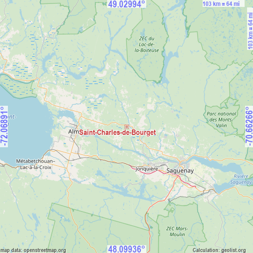
Saint-Charles-de-Bourget GPS coordinates[2]
48° 34' 0.444" North, 71° 21' 56.808" West
| Map corner | latitude | longitude |
|---|---|---|
| Upper-left | 49.02994°, | -72.06891° |
| Center: | 48.56679°, | -71.36578° |
| Lower-right: | 48.09936°, | -70.66266° |
| Map W x H: | 103.5×103.5 km | = 64.3×64.3mi |
| max Lat: | 73.03752° ⇑41.4% North |
| Saint-Charles-de-Bourget: | 48.56679° |
| min Lat: | ⇓58.6% South 42.05009° |
| min Long | Saint-Charles-d | max Long |
| -139.43328° | -71.36578° | -52.70931° |
| W 79.6%⇐ | ⇒20.4% E |
Elevation
Elevation of Saint-Charles-de-Bourget is 129 m = 423 ft, and this is 125.4 m = 411 ft below average elevation for this country.
| Max E: |
1518 m = 4980 ft | 56% |
| Avg. | 254.4 m = 835 ft | |
| Saint-Charles-de-Bourget | 129 m = 423 ft | |
Min E: |
-2 m = -7 ft | 44% |
See also: Canada elevation on elevation.city.
Geographical zone
Saint-Charles-de-Bourget is located in North temperate zone (between Tropic of Cancer and the Arctic Circle). Distance of this North polar circle is 2001.1 km =1243.4 mi to North.| Distance of | km | miles | from Saint-Charles-de-Bourget |
|---|---|---|---|
| North Pole | 4606.9 | 2862.6 | to North |
| Arctic Circle | 2001.1 | 1243.4 | to North |
| Tropic Cancer | 2794.2 | 1736.2 | to South |
| Equator | 5400.1 | 3355.5 | to South |


Nearby cities:
15 places around Saint-Charles-de-Bourget: (largest is in red/bold)
• Alma
20.9 km =13 mi,  264°
264°
• Chambord
53.7 km =33.4 mi,  253°
253°
• Jonquière
18.8 km =11.7 mi,  152°
152°
• L'Ascension-de-Notre-Seigneur
25.6 km =15.9 mi,  300°
300°
• Metabetchouan-Lac-a-la-Croix
35.2 km =21.9 mi,  240°
240°
• Métabetchouan
52.8 km =32.8 mi, 245°
• Pointe-du-Lac
31.6 km =19.6 mi, 256°
• Pont Rouge
63.3 km =39.3 mi, 303°
• Roberval
64 km =39.8 mi,  265°
265°
• Saguenay
27.7 km =17.2 mi,  127°
127°
• Saint-Ambroise
3.1 km =1.9 mi, 127°
• Saint-Bruno
23.6 km =14.7 mi, 241°
• Saint-Gédéon
30.4 km =18.9 mi, 255°
• Saint-Honoré
21.2 km =13.2 mi,  100°
100°
• Saint-Nazaire
14 km =8.7 mi,  280°
280°
Sources, notices
• [Note1] Compared only with cities in Canada existing in our database
• [Src1] Map data: © OpenStreetMap contributors (CC-BY-SA)
• [Src2] Other city data from geonames.org with taken over terms of usage.
• [Src3] Geographical zone / Annual Mean Temperature by Robert A. Rohde @ Wikipedia
