Amherstburg geodata
Amherstburg (Ontario) is a populated place; located in Canada in America/Toronto (GMT-4) time zone. With population of 13,910 people, there are 255 cities with bigger population in this country. Compared to other cities in Canada, 99.9% of cities are located further ↑North; 63.2% of cities are located further →East and 52% of cities have lower elevation than Amherstburg. Note1


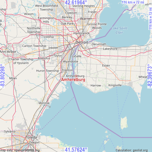
Amherstburg GPS coordinates[2]
42° 6' 0.324" North, 83° 5' 59.46" West
| Map corner | latitude | longitude |
|---|---|---|
| Upper-left | 42.61964°, | -83.80298° |
| Center: | 42.10009°, | -83.09985° |
| Lower-right: | 41.57624°, | -82.39673° |
| Map W x H: | 116×116 km | = 72.1×72.1mi |
| max Lat: | 73.03752° ⇑99.9% North |
| Amherstburg: | 42.10009° |
| min Lat: | ⇓0.1% South 42.05009° |
| min Long | Amherstburg | max Long |
| -139.43328° | -83.09985° | -52.70931° |
| W 36.8%⇐ | ⇒63.2% E |
Elevation
Elevation of Amherstburg is 181 m = 594 ft, and this is 73.4 m = 241 ft below average elevation for this country.
| Max E: |
1518 m = 4980 ft | 48% |
| Avg. | 254.4 m = 835 ft | |
| Amherstburg | 181 m = 594 ft | |
Min E: |
-2 m = -7 ft | 52% |
See also: Canada elevation on elevation.city.
Geographical zone
Amherstburg is located in North temperate zone (between Tropic of Cancer and the Arctic Circle). Distance of this Northern Tropic circle is 2075.2 km =1289.5 mi to South.| Distance of | km | miles | from Amherstburg |
|---|---|---|---|
| North Pole | 5326 | 3309.4 | to North |
| Arctic Circle | 2720.1 | 1690.2 | to North |
| Tropic Cancer | 2075.2 | 1289.5 | to South |
| Equator | 4681.1 | 2908.7 | to South |


Nearby cities:
15 places around Amherstburg: (largest is in red/bold)
• Bothwell
117.4 km =72.9 mi,  59°
59°
• Camlachie
129.3 km =80.3 mi,  36°
36°
• Chatham
82.9 km =51.5 mi,  65°
65°
• Corunna
102.8 km =63.9 mi,  32°
32°
• Essex
24.2 km =15 mi, 69°
• Glencoe
134.6 km =83.6 mi, 57°
• Lambton Shores
152.2 km =94.6 mi, 38°
• Leamington
41.6 km =25.8 mi,  97°
97°
• Petrolia
115.5 km =71.8 mi, 42°
• Ridgetown
105.5 km =65.6 mi, 69°
• Sarnia
113.1 km =70.3 mi, 30°
• Walpole Island
74.8 km =46.5 mi, 40°
• Watford
137.4 km =85.4 mi,  46°
46°
• West Lorne
135.2 km =84 mi, 65°
• Windsor
23.3 km =14.5 mi,  17°
17°
Sources, notices
• [Note1] Compared only with cities in Canada existing in our database
• [Src1] Map data: © OpenStreetMap contributors (CC-BY-SA)
• [Src2] Other city data from geonames.org with taken over terms of usage.
• [Src3] Geographical zone / Annual Mean Temperature by Robert A. Rohde @ Wikipedia
