Walpole Island geodata
Walpole Island (Ontario) is a populated locality; located in Canada in America/Detroit (GMT-4) time zone. With population of 1,878 people, there are 776 cities with bigger population in this country. Compared to other cities in Canada, 99.4% of cities are located further ↑North; 62.8% of cities are located further →East and 50.8% of cities have lower elevation than Walpole Island. Note1


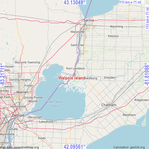
Walpole Island GPS coordinates[2]
42° 36' 54.72" North, 82° 30' 50.328" West
| Map corner | latitude | longitude |
|---|---|---|
| Upper-left | 43.13049°, | -83.21711° |
| Center: | 42.6152°, | -82.51398° |
| Lower-right: | 42.09561°, | -81.81086° |
| Map W x H: | 115.1×115.1 km | = 71.5×71.5mi |
| max Lat: | 73.03752° ⇑99.4% North |
| Walpole Island: | 42.6152° |
| min Lat: | ⇓0.6% South 42.05009° |
| min Long | Walpole Island | max Long |
| -139.43328° | -82.51398° | -52.70931° |
| W 37.2%⇐ | ⇒62.8% E |
Elevation
Elevation of Walpole Island is 176 m = 577 ft, and this is 78.4 m = 257 ft below average elevation for this country.
| Max E: |
1518 m = 4980 ft | 49.2% |
| Avg. | 254.4 m = 835 ft | |
| Walpole Island | 176 m = 577 ft | |
Min E: |
-2 m = -7 ft | 50.8% |
See also: Canada elevation on elevation.city.
Geographical zone
Walpole Island is located in North temperate zone (between Tropic of Cancer and the Arctic Circle). Distance of this Northern Tropic circle is 2132.4 km =1325 mi to South.| Distance of | km | miles | from Walpole Island |
|---|---|---|---|
| North Pole | 5268.7 | 3273.8 | to North |
| Arctic Circle | 2662.8 | 1654.6 | to North |
| Tropic Cancer | 2132.4 | 1325 | to South |
| Equator | 4738.4 | 2944.3 | to South |


Nearby cities:
15 places around Walpole Island: (largest is in red/bold)
• Amherstburg
74.8 km =46.5 mi,  220°
220°
• Bothwell
53 km =32.9 mi,  87°
87°
• Camlachie
54.9 km =34.1 mi,  31°
31°
• Chatham
35.2 km =21.9 mi,  129°
129°
• Corunna
30.5 km =19 mi,  12°
12°
• Essex
55.2 km =34.3 mi,  207°
207°
• Glencoe
66.9 km =41.6 mi,  77°
77°
• Lambton Shores
77.5 km =48.2 mi,  37°
37°
• Leamington
63.2 km =39.3 mi,  186°
186°
• Petrolia
40.8 km =25.4 mi,  46°
46°
• Ridgetown
54.2 km =33.7 mi,  111°
111°
• Sarnia
41.4 km =25.7 mi, 12°
• Watford
63.5 km =39.5 mi, 54°
• West Lorne
74.8 km =46.5 mi, 91°
• Windsor
54.1 km =33.6 mi,  229°
229°
Sources, notices
• [Note1] Compared only with cities in Canada existing in our database
• [Src1] Map data: © OpenStreetMap contributors (CC-BY-SA)
• [Src2] Other city data from geonames.org with taken over terms of usage.
• [Src3] Geographical zone / Annual Mean Temperature by Robert A. Rohde @ Wikipedia
