Glencoe geodata
Glencoe (Ontario) is a populated place; located in Canada in America/Toronto (GMT-4) time zone. With population of 2,126 people, there are 728 cities with bigger population in this country. Compared to other cities in Canada, 99.1% of cities are located further ↑North; 61.5% of cities are located further →East and 58.8% of cities have lower elevation than Glencoe. Note1


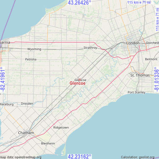
Glencoe GPS coordinates[2]
42° 45' 0.324" North, 81° 42' 59.328" West
| Map corner | latitude | longitude |
|---|---|---|
| Upper-left | 43.26426°, | -82.41961° |
| Center: | 42.75009°, | -81.71648° |
| Lower-right: | 42.23162°, | -81.01336° |
| Map W x H: | 114.8×114.8 km | = 71.3×71.3mi |
| max Lat: | 73.03752° ⇑99.1% North |
| Glencoe: | 42.75009° |
| min Lat: | ⇓0.9% South 42.05009° |
| min Long | Glencoe | max Long |
| -139.43328° | -81.71648° | -52.70931° |
| W 38.5%⇐ | ⇒61.5% E |
Elevation
Elevation of Glencoe is 223 m = 732 ft, and this is 31.4 m = 103 ft below average elevation for this country.
| Max E: |
1518 m = 4980 ft | 41.2% |
| Avg. | 254.4 m = 835 ft | |
| Glencoe | 223 m = 732 ft | |
Min E: |
-2 m = -7 ft | 58.8% |
See also: Canada elevation on elevation.city.
Geographical zone
Glencoe is located in North temperate zone (between Tropic of Cancer and the Arctic Circle). Distance of this Northern Tropic circle is 2147.4 km =1334.3 mi to South.| Distance of | km | miles | from Glencoe |
|---|---|---|---|
| North Pole | 5253.7 | 3264.5 | to North |
| Arctic Circle | 2647.8 | 1645.3 | to North |
| Tropic Cancer | 2147.4 | 1334.3 | to South |
| Equator | 4753.4 | 2953.6 | to South |


Nearby cities:
15 places around Glencoe: (largest is in red/bold)
• Belmont
53.7 km =33.4 mi,  73°
73°
• Bothwell
17.9 km =11.1 mi,  223°
223°
• Camlachie
48.2 km =30 mi,  311°
311°
• Chatham
53.7 km =33.4 mi,  225°
225°
• Delaware
30.7 km =19.1 mi,  52°
52°
• Lambton Shores
49.6 km =30.8 mi,  339°
339°
• London
47.2 km =29.3 mi,  56°
56°
• Mount Brydges
25.3 km =15.7 mi, 48°
• Parkhill
45.6 km =28.3 mi,  3°
3°
• Petrolia
37.7 km =23.4 mi,  290°
290°
• Port Stanley
41.9 km =26 mi,  102°
102°
• Ridgetown
38.3 km =23.8 mi,  203°
203°
• St. Thomas
43.8 km =27.2 mi,  86°
86°
• Watford
26.1 km =16.2 mi,  328°
328°
• West Lorne
19.2 km =11.9 mi,  150°
150°
Sources, notices
• [Note1] Compared only with cities in Canada existing in our database
• [Src1] Map data: © OpenStreetMap contributors (CC-BY-SA)
• [Src2] Other city data from geonames.org with taken over terms of usage.
• [Src3] Geographical zone / Annual Mean Temperature by Robert A. Rohde @ Wikipedia
