Lambton Shores geodata
Lambton Shores (Ontario) is a populated place; located in Canada in America/Toronto (GMT-4) time zone. With population of 10,656 people, there are 298 cities with bigger population in this country. Compared to other cities in Canada, 96.5% of cities are located further ↑North; 62% of cities are located further →East and 56.1% of cities have lower elevation than Lambton Shores. Note1


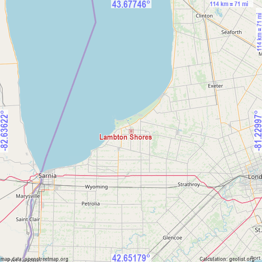
Lambton Shores GPS coordinates[2]
43° 10' 0.408" North, 81° 55' 59.124" West
| Map corner | latitude | longitude |
|---|---|---|
| Upper-left | 43.67746°, | -82.63622° |
| Center: | 43.16678°, | -81.93309° |
| Lower-right: | 42.65179°, | -81.22997° |
| Map W x H: | 114×114 km | = 70.8×70.8mi |
| max Lat: | 73.03752° ⇑96.5% North |
| Lambton Shores: | 43.16678° |
| min Lat: | ⇓3.5% South 42.05009° |
| min Long | Lambton Shores | max Long |
| -139.43328° | -81.93309° | -52.70931° |
| W 38%⇐ | ⇒62% E |
Elevation
Elevation of Lambton Shores is 207 m = 679 ft, and this is 47.4 m = 156 ft below average elevation for this country.
| Max E: |
1518 m = 4980 ft | 43.9% |
| Avg. | 254.4 m = 835 ft | |
| Lambton Shores | 207 m = 679 ft | |
Min E: |
-2 m = -7 ft | 56.1% |
See also: Canada elevation on elevation.city.
Geographical zone
Lambton Shores is located in North temperate zone (between Tropic of Cancer and the Arctic Circle). Distance of this Northern Tropic circle is 2193.8 km =1363.2 mi to South.| Distance of | km | miles | from Lambton Shores |
|---|---|---|---|
| North Pole | 5207.4 | 3235.7 | to North |
| Arctic Circle | 2601.5 | 1616.5 | to North |
| Tropic Cancer | 2193.8 | 1363.2 | to South |
| Equator | 4799.7 | 2982.4 | to South |


Nearby cities:
15 places around Lambton Shores: (largest is in red/bold)
• Bluewater
42.9 km =26.7 mi,  38°
38°
• Bothwell
59.6 km =37 mi,  174°
174°
• Camlachie
23.6 km =14.7 mi,  231°
231°
• Corunna
51.4 km =31.9 mi, 232°
• Delaware
50.4 km =31.3 mi,  123°
123°
• Glencoe
49.6 km =30.8 mi,  159°
159°
• London
60.4 km =37.5 mi,  109°
109°
• Lucan
43.3 km =26.9 mi,  87°
87°
• Mount Brydges
47.1 km =29.3 mi,  129°
129°
• Parkhill
20.2 km =12.6 mi, 92°
• Petrolia
37.7 km =23.4 mi,  207°
207°
• Sarnia
43.6 km =27.1 mi,  241°
241°
• Seaforth
60.6 km =37.7 mi,  45°
45°
• South Huron
37.6 km =23.4 mi,  63°
63°
• Watford
24.4 km =15.2 mi, 170°
Sources, notices
• [Note1] Compared only with cities in Canada existing in our database
• [Src1] Map data: © OpenStreetMap contributors (CC-BY-SA)
• [Src2] Other city data from geonames.org with taken over terms of usage.
• [Src3] Geographical zone / Annual Mean Temperature by Robert A. Rohde @ Wikipedia
