Bothwell geodata
Bothwell (Ontario) is a populated place; located in Canada in America/Toronto (GMT-4) time zone. With population of 856 people, there are 1085 cities with bigger population in this country. Compared to other cities in Canada, 99.2% of cities are located further ↑North; 61.7% of cities are located further →East and 56.6% of cities have lower elevation than Bothwell. Note1


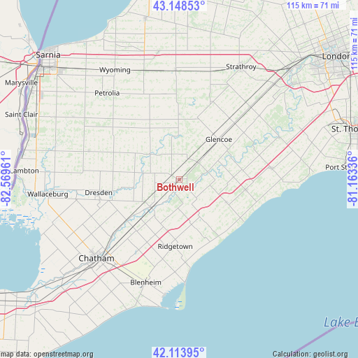
Bothwell GPS coordinates[2]
42° 38' 0.204" North, 81° 51' 59.328" West
| Map corner | latitude | longitude |
|---|---|---|
| Upper-left | 43.14853°, | -82.56961° |
| Center: | 42.63339°, | -81.86648° |
| Lower-right: | 42.11395°, | -81.16336° |
| Map W x H: | 115×115 km | = 71.5×71.5mi |
| max Lat: | 73.03752° ⇑99.2% North |
| Bothwell: | 42.63339° |
| min Lat: | ⇓0.8% South 42.05009° |
| min Long | Bothwell | max Long |
| -139.43328° | -81.86648° | -52.70931° |
| W 38.3%⇐ | ⇒61.7% E |
Elevation
Elevation of Bothwell is 210 m = 689 ft, and this is 44.4 m = 146 ft below average elevation for this country.
| Max E: |
1518 m = 4980 ft | 43.4% |
| Avg. | 254.4 m = 835 ft | |
| Bothwell | 210 m = 689 ft | |
Min E: |
-2 m = -7 ft | 56.6% |
See also: Canada elevation on elevation.city.
Geographical zone
Bothwell is located in North temperate zone (between Tropic of Cancer and the Arctic Circle). Distance of this Northern Tropic circle is 2134.5 km =1326.3 mi to South.| Distance of | km | miles | from Bothwell |
|---|---|---|---|
| North Pole | 5266.7 | 3272.6 | to North |
| Arctic Circle | 2660.8 | 1653.3 | to North |
| Tropic Cancer | 2134.5 | 1326.3 | to South |
| Equator | 4740.4 | 2945.5 | to South |


Nearby cities:
15 places around Bothwell: (largest is in red/bold)
• Camlachie
50.8 km =31.6 mi,  331°
331°
• Chatham
35.9 km =22.3 mi,  226°
226°
• Corunna
54 km =33.6 mi,  301°
301°
• Delaware
48.4 km =30.1 mi,  49°
49°
• Glencoe
17.9 km =11.1 mi,  43°
43°
• Lambton Shores
59.6 km =37 mi,  354°
354°
• Mount Brydges
43.1 km =26.8 mi, 46°
• Petrolia
34.8 km =21.6 mi,  318°
318°
• Port Stanley
53.3 km =33.1 mi,  86°
86°
• Ridgetown
22.4 km =13.9 mi,  186°
186°
• Sarnia
58.3 km =36.2 mi,  311°
311°
• St. Thomas
58.2 km =36.2 mi,  74°
74°
• Walpole Island
53 km =32.9 mi,  267°
267°
• Watford
35.2 km =21.9 mi,  357°
357°
• West Lorne
22.1 km =13.7 mi,  99°
99°
Sources, notices
• [Note1] Compared only with cities in Canada existing in our database
• [Src1] Map data: © OpenStreetMap contributors (CC-BY-SA)
• [Src2] Other city data from geonames.org with taken over terms of usage.
• [Src3] Geographical zone / Annual Mean Temperature by Robert A. Rohde @ Wikipedia
