Camlachie geodata
Camlachie (Ontario) is a populated place; located in Canada in America/Toronto (GMT-4) time zone. With population of 7,506 people, there are 381 cities with bigger population in this country. Compared to other cities in Canada, 97.3% of cities are located further ↑North; 62.2% of cities are located further →East and 55% of cities have lower elevation than Camlachie. Note1


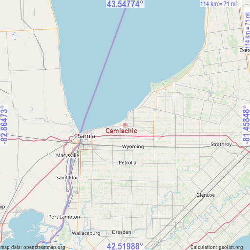
Camlachie GPS coordinates[2]
43° 2' 9.456" North, 82° 9' 41.76" West
| Map corner | latitude | longitude |
|---|---|---|
| Upper-left | 43.54774°, | -82.86473° |
| Center: | 43.03596°, | -82.1616° |
| Lower-right: | 42.51988°, | -81.45848° |
| Map W x H: | 114.3×114.3 km | = 71×71mi |
| max Lat: | 73.03752° ⇑97.3% North |
| Camlachie: | 43.03596° |
| min Lat: | ⇓2.7% South 42.05009° |
| min Long | Camlachie | max Long |
| -139.43328° | -82.1616° | -52.70931° |
| W 37.8%⇐ | ⇒62.2% E |
Elevation
Elevation of Camlachie is 200 m = 656 ft, and this is 54.4 m = 178 ft below average elevation for this country.
| Max E: |
1518 m = 4980 ft | 45% |
| Avg. | 254.4 m = 835 ft | |
| Camlachie | 200 m = 656 ft | |
Min E: |
-2 m = -7 ft | 55% |
See also: Canada elevation on elevation.city.
Geographical zone
Camlachie is located in North temperate zone (between Tropic of Cancer and the Arctic Circle). Distance of this Northern Tropic circle is 2179.2 km =1354.1 mi to South.| Distance of | km | miles | from Camlachie |
|---|---|---|---|
| North Pole | 5221.9 | 3244.7 | to North |
| Arctic Circle | 2616 | 1625.5 | to North |
| Tropic Cancer | 2179.2 | 1354.1 | to South |
| Equator | 4785.2 | 2973.4 | to South |


Nearby cities:
15 places around Camlachie: (largest is in red/bold)
• Bluewater
66.1 km =41.1 mi,  43°
43°
• Bothwell
50.8 km =31.6 mi,  151°
151°
• Corunna
27.9 km =17.3 mi,  232°
232°
• Delaware
62 km =38.5 mi,  102°
102°
• Glencoe
48.2 km =30 mi,  131°
131°
• Lambton Shores
23.6 km =14.7 mi,  51°
51°
• Lucan
64 km =39.8 mi,  75°
75°
• Mount Brydges
57.2 km =35.5 mi,  105°
105°
• Parkhill
41.1 km =25.5 mi,  70°
70°
• Petrolia
18.8 km =11.7 mi,  177°
177°
• Sarnia
20.7 km =12.9 mi,  252°
252°
• South Huron
60.9 km =37.8 mi,  59°
59°
• Walpole Island
54.9 km =34.1 mi,  211°
211°
• Watford
24.6 km =15.3 mi, 112°
• West Lorne
66.7 km =41.4 mi,  136°
136°
Sources, notices
• [Note1] Compared only with cities in Canada existing in our database
• [Src1] Map data: © OpenStreetMap contributors (CC-BY-SA)
• [Src2] Other city data from geonames.org with taken over terms of usage.
• [Src3] Geographical zone / Annual Mean Temperature by Robert A. Rohde @ Wikipedia
