West Lorne geodata
West Lorne (Ontario) is a populated place; located in Canada in America/Toronto (GMT-4) time zone. With population of 1,337 people, there are 905 cities with bigger population in this country. Compared to other cities in Canada, 99.5% of cities are located further ↑North; 60.9% of cities are located further →East and 57.3% of cities have lower elevation than West Lorne. Note1


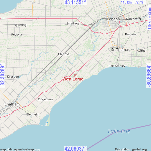
West Lorne GPS coordinates[2]
42° 36' 0.324" North, 81° 35' 59.136" West
| Map corner | latitude | longitude |
|---|---|---|
| Upper-left | 43.11551°, | -82.30289° |
| Center: | 42.60009°, | -81.59976° |
| Lower-right: | 42.08037°, | -80.89664° |
| Map W x H: | 115.1×115.1 km | = 71.5×71.5mi |
| max Lat: | 73.03752° ⇑99.5% North |
| West Lorne: | 42.60009° |
| min Lat: | ⇓0.5% South 42.05009° |
| min Long | West Lorne | max Long |
| -139.43328° | -81.59976° | -52.70931° |
| W 39.1%⇐ | ⇒60.9% E |
Elevation
Elevation of West Lorne is 216 m = 709 ft, and this is 38.4 m = 126 ft below average elevation for this country.
| Max E: |
1518 m = 4980 ft | 42.7% |
| Avg. | 254.4 m = 835 ft | |
| West Lorne | 216 m = 709 ft | |
Min E: |
-2 m = -7 ft | 57.3% |
See also: Canada elevation on elevation.city.
Geographical zone
West Lorne is located in North temperate zone (between Tropic of Cancer and the Arctic Circle). Distance of this Northern Tropic circle is 2130.8 km =1324 mi to South.| Distance of | km | miles | from West Lorne |
|---|---|---|---|
| North Pole | 5270.4 | 3274.9 | to North |
| Arctic Circle | 2664.5 | 1655.6 | to North |
| Tropic Cancer | 2130.8 | 1324 | to South |
| Equator | 4736.7 | 2943.2 | to South |


Nearby cities:
15 places around West Lorne: (largest is in red/bold)
• Aylmer
53.7 km =33.4 mi,  69°
69°
• Belmont
52.7 km =32.7 mi,  53°
53°
• Bothwell
22.1 km =13.7 mi,  279°
279°
• Chatham
52.3 km =32.5 mi,  246°
246°
• Delaware
38.3 km =23.8 mi,  23°
23°
• Dorchester
60.9 km =37.8 mi, 45°
• Glencoe
19.2 km =11.9 mi,  330°
330°
• London
52.1 km =32.4 mi,  35°
35°
• Mount Brydges
34.7 km =21.6 mi, 15°
• Parkhill
62.6 km =38.9 mi,  353°
353°
• Petrolia
53.8 km =33.4 mi,  303°
303°
• Port Stanley
32.2 km =20 mi,  76°
76°
• Ridgetown
30.8 km =19.1 mi,  232°
232°
• St. Thomas
39.3 km =24.4 mi,  60°
60°
• Watford
45.3 km =28.1 mi, 329°
Sources, notices
• [Note1] Compared only with cities in Canada existing in our database
• [Src1] Map data: © OpenStreetMap contributors (CC-BY-SA)
• [Src2] Other city data from geonames.org with taken over terms of usage.
• [Src3] Geographical zone / Annual Mean Temperature by Robert A. Rohde @ Wikipedia
