Huntsville geodata
Huntsville (Ontario) is a populated place; located in Canada in America/Toronto (GMT-4) time zone. With population of 19,579 people, there are 190 cities with bigger population in this country. Compared to other cities in Canada, 79.9% of cities are located further ↑North; 50.8% of cities are located further →East and 69.6% of cities have lower elevation than Huntsville. Note1


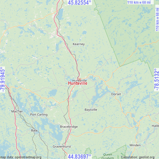
Huntsville GPS coordinates[2]
45° 20' 0.276" North, 79° 12' 58.752" West
| Map corner | latitude | longitude |
|---|---|---|
| Upper-left | 45.82554°, | -79.91945° |
| Center: | 45.33341°, | -79.21632° |
| Lower-right: | 44.83697°, | -78.5132° |
| Map W x H: | 109.9×109.9 km | = 68.3×68.3mi |
| max Lat: | 73.03752° ⇑79.9% North |
| Huntsville: | 45.33341° |
| min Lat: | ⇓20.1% South 42.05009° |
| min Long | Huntsville | max Long |
| -139.43328° | -79.21632° | -52.70931° |
| W 49.2%⇐ | ⇒50.8% E |
Elevation
Elevation of Huntsville is 302 m = 991 ft, and this is 47.6 m = 156 ft above average elevation for this country.
| Max E: |
1518 m = 4980 ft | 30.4% |
| Huntsville | 302 m 991 ft | |
| Avg. | 254.4 m = 835 ft | |
Min E: |
-2 m = -7 ft | 69.6% |
See also: Canada elevation on elevation.city.
Geographical zone
Huntsville is located in North temperate zone (between Tropic of Cancer and the Arctic Circle). Distance of this North polar circle is 2360.6 km =1466.8 mi to North.| Distance of | km | miles | from Huntsville |
|---|---|---|---|
| North Pole | 4966.5 | 3086 | to North |
| Arctic Circle | 2360.6 | 1466.8 | to North |
| Tropic Cancer | 2434.7 | 1512.9 | to South |
| Equator | 5040.6 | 3132.1 | to South |


Nearby cities:
15 places around Huntsville: (largest is in red/bold)
• Amigo Beach
71.9 km =44.7 mi,  191°
191°
• Anten Mills
105.9 km =65.8 mi,  206°
206°
• Bancroft
110.8 km =68.8 mi,  106°
106°
• Barrie
109.7 km =68.2 mi,  198°
198°
• Bracebridge
34.3 km =21.3 mi, 193°
• Elmvale
97.8 km =60.8 mi, 211°
• Gravenhurst
47.8 km =29.7 mi, 194°
• Haliburton Village
62.8 km =39 mi,  119°
119°
• Midland
83.4 km =51.8 mi,  218°
218°
• Orillia
82.2 km =51.1 mi, 191°
• Parry Sound
64 km =39.8 mi,  271°
271°
• Patrick Fogarty Catholic Secondary School
80.5 km =50 mi, 192°
• Powassan
78.5 km =48.8 mi,  352°
352°
• South River
57.1 km =35.5 mi, 346°
• Wasaga Beach
110.5 km =68.7 mi, 214°
Sources, notices
• [Note1] Compared only with cities in Canada existing in our database
• [Src1] Map data: © OpenStreetMap contributors (CC-BY-SA)
• [Src2] Other city data from geonames.org with taken over terms of usage.
• [Src3] Geographical zone / Annual Mean Temperature by Robert A. Rohde @ Wikipedia
