Chibougamau geodata
Chibougamau (Quebec) is a populated place; located in Canada in America/Toronto (GMT-4) time zone. With population of 7,563 people, there are 376 cities with bigger population in this country. Compared to other cities in Canada, 75.2% of cities are located further ↓South; 59.6% of cities are located further ←West and 78.4% of cities have lower elevation than Chibougamau. Note1


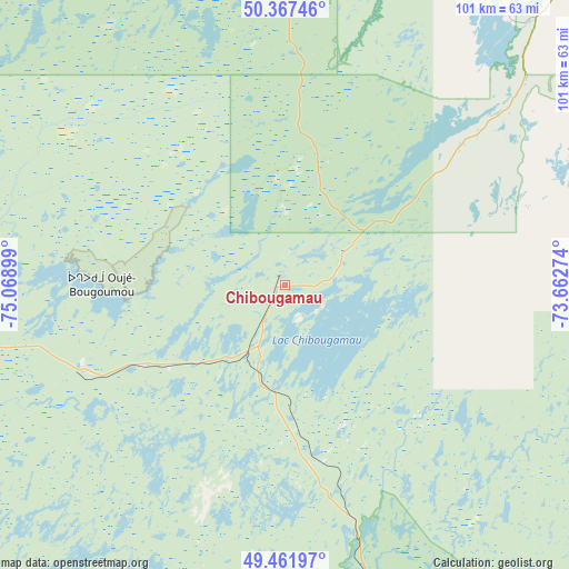
Chibougamau GPS coordinates[2]
49° 55' 0.624" North, 74° 21' 57.096" West
| Map corner | latitude | longitude |
|---|---|---|
| Upper-left | 50.36746°, | -75.06899° |
| Center: | 49.91684°, | -74.36586° |
| Lower-right: | 49.46197°, | -73.66274° |
| Map W x H: | 100.7×100.7 km | = 62.6×62.6mi |
| max Lat: | 73.03752° ⇑24.8% North |
| Chibougamau: | 49.91684° |
| min Lat: | ⇓75.2% South 42.05009° |
| min Long | Chibougamau | max Long |
| -139.43328° | -74.36586° | -52.70931° |
| W 59.6%⇐ | ⇒40.4% E |
Elevation
Elevation of Chibougamau is 407 m = 1335 ft, and this is 152.6 m = 501 ft above average elevation for this country.
| Max E: |
1518 m = 4980 ft | 21.6% |
| Chibougamau | 407 m 1335 ft | |
| Avg. | 254.4 m = 835 ft | |
Min E: |
-2 m = -7 ft | 78.4% |
See also: Canada elevation on elevation.city.
Geographical zone
Chibougamau is located in North temperate zone (between Tropic of Cancer and the Arctic Circle). Distance of this North polar circle is 1850.9 km =1150.1 mi to North.| Distance of | km | miles | from Chibougamau |
|---|---|---|---|
| North Pole | 4456.8 | 2769.3 | to North |
| Arctic Circle | 1850.9 | 1150.1 | to North |
| Tropic Cancer | 2944.3 | 1829.5 | to South |
| Equator | 5550.2 | 3448.7 | to South |


Nearby cities:
15 places around Chibougamau: (largest is in red/bold)
• Albanel
180.1 km =111.9 mi,  129°
129°
• Chambord
234.8 km =145.9 mi, 134°
• Chapais
37.7 km =23.4 mi,  246°
246°
• Dolbeau-Mistassini
192.8 km =119.8 mi, 126°
• Lebel-sur-Quévillon
212.2 km =131.9 mi,  242°
242°
• Leblanc
183.5 km =114 mi,  179°
179°
• Mistissini
65.3 km =40.6 mi,  31°
31°
• Normandin
179.3 km =111.4 mi, 132°
• Pont Rouge
201.2 km =125 mi,  124°
124°
• Roberval
219.6 km =136.5 mi,  135°
135°
• Saint-Félicien
197.9 km =123 mi, 135°
• Saint-Prime
209.2 km =130 mi, 135°
• Scott
19.1 km =11.9 mi,  234°
234°
• Waswanipi
130.7 km =81.2 mi,  261°
261°
• Weymontachie
228.4 km =141.9 mi,  169°
169°
Sources, notices
• [Note1] Compared only with cities in Canada existing in our database
• [Src1] Map data: © OpenStreetMap contributors (CC-BY-SA)
• [Src2] Other city data from geonames.org with taken over terms of usage.
• [Src3] Geographical zone / Annual Mean Temperature by Robert A. Rohde @ Wikipedia
