Lebel-sur-Quévillon geodata
Lebel-sur-Quévillon (Quebec) is a populated place; located in Canada in America/Toronto (GMT-4) time zone. With population of 3,289 people, there are 583 cities with bigger population in this country. Compared to other cities in Canada, 62.5% of cities are located further ↓South; 53.3% of cities are located further ←West and 68.4% of cities have lower elevation than Lebel-sur-Quévillon. Note1


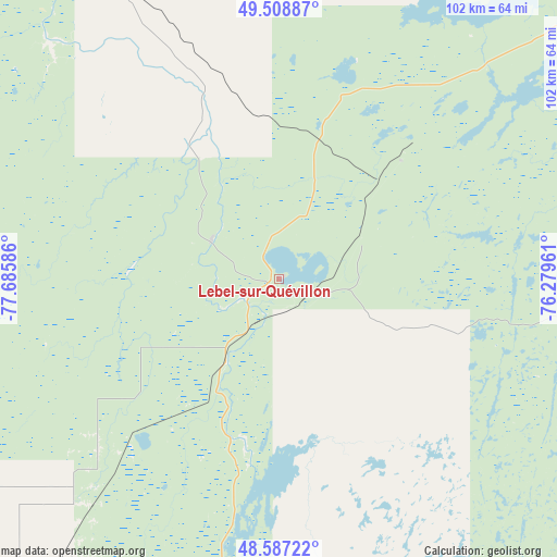
Lebel-sur-Quévillon GPS coordinates[2]
49° 3' 0.648" North, 76° 58' 57.828" West
| Map corner | latitude | longitude |
|---|---|---|
| Upper-left | 49.50887°, | -77.68586° |
| Center: | 49.05018°, | -76.98273° |
| Lower-right: | 48.58722°, | -76.27961° |
| Map W x H: | 102.5×102.5 km | = 63.7×63.7mi |
| max Lat: | 73.03752° ⇑37.5% North |
| Lebel-sur-Quévillon: | 49.05018° |
| min Lat: | ⇓62.5% South 42.05009° |
| min Long | Lebel-sur-Quév | max Long |
| -139.43328° | -76.98273° | -52.70931° |
| W 53.3%⇐ | ⇒46.7% E |
Elevation
Elevation of Lebel-sur-Quévillon is 281 m = 922 ft, and this is 26.6 m = 87 ft above average elevation for this country.
| Max E: |
1518 m = 4980 ft | 31.6% |
| Lebel-sur-Quévillon | 281 m 922 ft | |
| Avg. | 254.4 m = 835 ft | |
Min E: |
-2 m = -7 ft | 68.4% |
See also: Canada elevation on elevation.city.
Geographical zone
Lebel-sur-Quévillon is located in North temperate zone (between Tropic of Cancer and the Arctic Circle). Distance of this North polar circle is 1947.3 km =1210 mi to North.| Distance of | km | miles | from Lebel-sur-Quévillon |
|---|---|---|---|
| North Pole | 4553.2 | 2829.2 | to North |
| Arctic Circle | 1947.3 | 1210 | to North |
| Tropic Cancer | 2847.9 | 1769.6 | to South |
| Equator | 5453.9 | 3388.9 | to South |


Nearby cities:
15 places around Lebel-sur-Quévillon: (largest is in red/bold)
• Amos
98.9 km =61.5 mi,  237°
237°
• Barraute
83.5 km =51.9 mi,  214°
214°
• Chapais
174.5 km =108.4 mi,  62°
62°
• Chibougamau
212.2 km =131.9 mi, 62°
• Kirkland Lake
246.2 km =153 mi,  245°
245°
• La Sarre
164.3 km =102.1 mi,  260°
260°
• Leblanc
212.1 km =131.8 mi,  114°
114°
• Macamic
151.1 km =93.9 mi, 257°
• Malartic
132.4 km =82.3 mi,  219°
219°
• Matagami
90.9 km =56.5 mi,  328°
328°
• Rouyn-Noranda
175.1 km =108.8 mi, 238°
• Scott
193.4 km =120.2 mi, 63°
• Senneterre
75.5 km =46.9 mi,  194°
194°
• Val-d'Or
121.7 km =75.6 mi, 209°
• Waswanipi
96.3 km =59.8 mi,  37°
37°
Sources, notices
• [Note1] Compared only with cities in Canada existing in our database
• [Src1] Map data: © OpenStreetMap contributors (CC-BY-SA)
• [Src2] Other city data from geonames.org with taken over terms of usage.
• [Src3] Geographical zone / Annual Mean Temperature by Robert A. Rohde @ Wikipedia
