Gatineau geodata
Gatineau (Quebec) is a populated place; located in Canada in America/Toronto (GMT-4) time zone. With population of 242,124 people, there are 23 cities with bigger population in this country. Compared to other cities in Canada, 75.3% of cities are located further ↑North; 55.8% of cities are located further ←West and 70.8% of cities have higher elevation than Gatineau. Note1


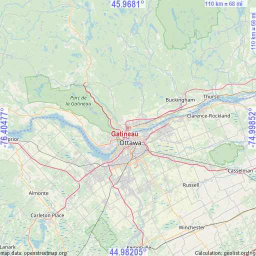
Gatineau GPS coordinates[2]
45° 28' 38.028" North, 75° 42' 5.904" West
| Map corner | latitude | longitude |
|---|---|---|
| Upper-left | 45.9681°, | -76.40477° |
| Center: | 45.47723°, | -75.70164° |
| Lower-right: | 44.98205°, | -74.99852° |
| Map W x H: | 109.6×109.6 km | = 68.1×68.1mi |
| max Lat: | 73.03752° ⇑75.3% North |
| Gatineau: | 45.47723° |
| min Lat: | ⇓24.7% South 42.05009° |
| min Long | Gatineau | max Long |
| -139.43328° | -75.70164° | -52.70931° |
| W 55.8%⇐ | ⇒44.2% E |
Elevation
Elevation of Gatineau is 53 m = 174 ft, and this is 201.4 m = 661 ft below average elevation for this country.
| Max E: |
1518 m = 4980 ft | 70.8% |
| Avg. | 254.4 m = 835 ft | |
| Gatineau | 53 m = 174 ft | |
Min E: |
-2 m = -7 ft | 29.2% |
See also: Gatineau elevation on elevation.city.
Geographical zone
Gatineau is located in North temperate zone (between Tropic of Cancer and the Arctic Circle). Distance of this North polar circle is 2344.6 km =1456.9 mi to North.| Distance of | km | miles | from Gatineau |
|---|---|---|---|
| North Pole | 4950.5 | 3076.1 | to North |
| Arctic Circle | 2344.6 | 1456.9 | to North |
| Tropic Cancer | 2450.7 | 1522.8 | to South |
| Equator | 5056.6 | 3142 | to South |


Nearby cities:
15 places around Gatineau: (largest is in red/bold)
• Bells Corners
20.6 km =12.8 mi,  209°
209°
• Buckingham
25 km =15.5 mi,  61°
61°
• Cantley
11.8 km =7.3 mi,  327°
327°
• Constance Bay
29.8 km =18.5 mi,  274°
274°
• Fallingbrook
17 km =10.6 mi,  90°
90°
• Kanata
25.9 km =16.1 mi,  220°
220°
• Metcalfe
32.8 km =20.4 mi,  145°
145°
• Nepean
14.2 km =8.8 mi,  192°
192°
• Ottawa
7.4 km =4.6 mi,  177°
177°
• Queenswood Heights
15.3 km =9.5 mi, 92°
• Saint-Alexandre
4.5 km =2.8 mi,  304°
304°
• Val-des-Monts
19.4 km =12.1 mi,  8°
8°
• Vanier
5 km =3.1 mi, 145°
• Wakefield
23.4 km =14.5 mi, 334°
• le Plateau
7.7 km =4.8 mi,  232°
232°
Sources, notices
• [Note1] Compared only with cities in Canada existing in our database
• [Src1] Map data: © OpenStreetMap contributors (CC-BY-SA)
• [Src2] Other city data from geonames.org with taken over terms of usage.
• [Src3] Geographical zone / Annual Mean Temperature by Robert A. Rohde @ Wikipedia
