Val-des-Monts geodata
Val-des-Monts (Quebec) is a populated place; located in Canada in America/Toronto (GMT-4) time zone. With population of 9,539 people, there are 325 cities with bigger population in this country. Compared to other cities in Canada, 70.5% of cities are located further ↑North; 56.1% of cities are located further ←West and 54.9% of cities have higher elevation than Val-des-Monts. Note1


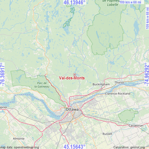
Val-des-Monts GPS coordinates[2]
45° 39' 0.36" North, 75° 39' 57.744" West
| Map corner | latitude | longitude |
|---|---|---|
| Upper-left | 46.13946°, | -76.36917° |
| Center: | 45.6501°, | -75.66604° |
| Lower-right: | 45.15643°, | -74.96292° |
| Map W x H: | 109.3×109.3 km | = 67.9×67.9mi |
| max Lat: | 73.03752° ⇑70.5% North |
| Val-des-Monts: | 45.6501° |
| min Lat: | ⇓29.5% South 42.05009° |
| min Long | Val-des-Monts | max Long |
| -139.43328° | -75.66604° | -52.70931° |
| W 56.1%⇐ | ⇒43.9% E |
Elevation
Elevation of Val-des-Monts is 141 m = 463 ft, and this is 113.4 m = 372 ft below average elevation for this country.
| Max E: |
1518 m = 4980 ft | 54.9% |
| Avg. | 254.4 m = 835 ft | |
| Val-des-Monts | 141 m = 463 ft | |
Min E: |
-2 m = -7 ft | 45.1% |
See also: Canada elevation on elevation.city.
Geographical zone
Val-des-Monts is located in North temperate zone (between Tropic of Cancer and the Arctic Circle). Distance of this North polar circle is 2325.4 km =1444.9 mi to North.| Distance of | km | miles | from Val-des-Monts |
|---|---|---|---|
| North Pole | 4931.2 | 3064.1 | to North |
| Arctic Circle | 2325.4 | 1444.9 | to North |
| Tropic Cancer | 2469.9 | 1534.7 | to South |
| Equator | 5075.8 | 3154 | to South |


Nearby cities:
15 places around Val-des-Monts: (largest is in red/bold)
• Bells Corners
39.3 km =24.4 mi,  198°
198°
• Buckingham
20.4 km =12.7 mi,  110°
110°
• Cantley
13 km =8.1 mi,  224°
224°
• Clarence-Rockland
31.2 km =19.4 mi, 110°
• Constance Bay
36.5 km =22.7 mi,  242°
242°
• Fallingbrook
24 km =14.9 mi,  143°
143°
• Gatineau
19.4 km =12.1 mi,  188°
188°
• Nepean
33.6 km =20.9 mi, 189°
• Ottawa
26.7 km =16.6 mi, 185°
• Queenswood Heights
23.5 km =14.6 mi,  147°
147°
• Saint-Alexandre
17.9 km =11.1 mi, 201°
• Thurso
32.9 km =20.4 mi,  99°
99°
• Vanier
23.4 km =14.5 mi,  179°
179°
• Wakefield
13.1 km =8.1 mi,  278°
278°
• le Plateau
25.5 km =15.8 mi, 200°
Sources, notices
• [Note1] Compared only with cities in Canada existing in our database
• [Src1] Map data: © OpenStreetMap contributors (CC-BY-SA)
• [Src2] Other city data from geonames.org with taken over terms of usage.
• [Src3] Geographical zone / Annual Mean Temperature by Robert A. Rohde @ Wikipedia
