Clyde River geodata
Clyde River (Nunavut) is a populated locality; located in Canada in America/Iqaluit (GMT-4) time zone. With population of 1,017 people, there are 1041 cities with bigger population in this country. Compared to other cities in Canada, 99.9% of cities are located further ↓South; 84.3% of cities are located further ←West and 93.8% of cities have higher elevation than Clyde River. Note1


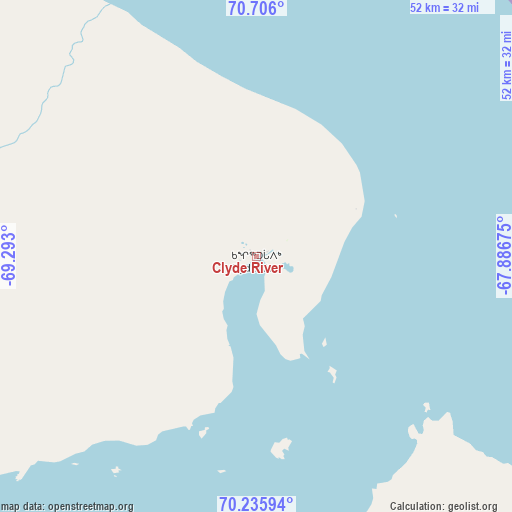
Clyde River GPS coordinates[2]
70° 28' 20.388" North, 68° 35' 23.532" West
| Map corner | latitude | longitude |
|---|---|---|
| Upper-left | 70.706°, | -69.293° |
| Center: | 70.47233°, | -68.58987° |
| Lower-right: | 70.23594°, | -67.88675° |
| Map W x H: | 52.3×52.3 km | = 32.5×32.5mi |
| max Lat: | 73.03752° ⇑0.1% North |
| Clyde River: | 70.47233° |
| min Lat: | ⇓99.9% South 42.05009° |
| min Long | Clyde River | max Long |
| -139.43328° | -68.58987° | -52.70931° |
| W 84.3%⇐ | ⇒15.7% E |
Elevation
Elevation of Clyde River is 10 m = 33 ft, and this is 244.4 m = 802 ft below average elevation for this country.
| Max E: |
1518 m = 4980 ft | 93.8% |
| Avg. | 254.4 m = 835 ft | |
| Clyde River | 10 m = 33 ft | |
Min E: |
-2 m = -7 ft | 6.2% |
See also: Canada elevation on elevation.city.
Geographical zone
Clyde River is located in North Frigid zone (between North Pole and Arctic Circle). Distance of this North polar circle is 434.6 km =270 mi to South.| Distance of | km | miles | from Clyde River |
|---|---|---|---|
| North Pole | 2171.3 | 1349.2 | to North |
| Arctic Circle | 434.6 | 270 | to South |
| Tropic Cancer | 5229.9 | 3249.7 | to South |
| Equator | 7835.8 | 4868.9 | to South |


Nearby cities:
15 places around Clyde River: (largest is in red/bold)
• Arctic Bay
640.3 km =397.9 mi,  296°
296°
• Attawapiskat
2070.6 km =1286.6 mi,  199°
199°
• Churchill Falls
1897.5 km =1179.1 mi,  172°
172°
• Fermont
1968.3 km =1223 mi,  177°
177°
• Fort Albany
2137 km =1327.9 mi, 198°
• Gjoa Haven
1070.2 km =665 mi,  259°
259°
• Godefroy
2081.9 km =1293.6 mi, 179°
• Happy Valley-Goose Bay
1953.2 km =1213.7 mi, 167°
• Hopedale
1717.5 km =1067.2 mi, 166°
• Iqaluit
747.8 km =464.7 mi, 179°
• Kugluktuk
1816.8 km =1128.9 mi, 260°
• Labrador City
1950.5 km =1212 mi, 177°
• Pangnirtung
495.3 km =307.8 mi, 166°
• Rankin Inlet
1326.4 km =824.2 mi,  230°
230°
• Salluit
970.2 km =602.9 mi, 198°
Sources, notices
• [Note1] Compared only with cities in Canada existing in our database
• [Src1] Map data: © OpenStreetMap contributors (CC-BY-SA)
• [Src2] Other city data from geonames.org with taken over terms of usage.
• [Src3] Geographical zone / Annual Mean Temperature by Robert A. Rohde @ Wikipedia
