Salluit geodata
Salluit (Quebec) is a populated place; located in Canada in America/Toronto (GMT-4) time zone. With population of 1,075 people, there are 1011 cities with bigger population in this country. Compared to other cities in Canada, 98.4% of cities are located further ↓South; 56.2% of cities are located further ←West and 78.3% of cities have higher elevation than Salluit. Note1


Salluit GPS coordinates[2]
62° 12' 14.796" North, 75° 38' 36.384" West
| Map corner | latitude | longitude |
|---|---|---|
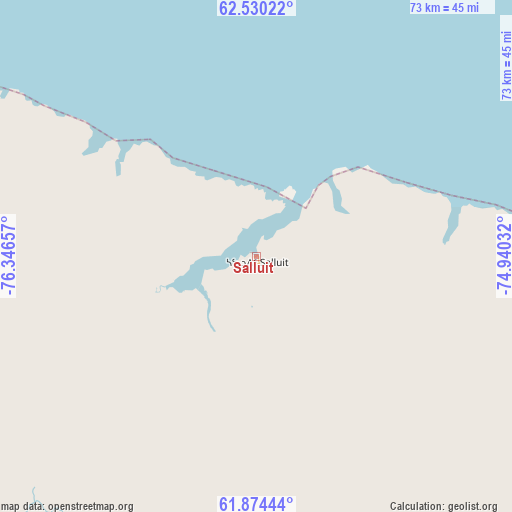
| Upper-left | 62.53022°, | -76.34657° |
| Center: | 62.20411°, | -75.64344° |
| Lower-right: | 61.87444°, | -74.94032° |
| Map W x H: | 72.9×72.9 km | = 45.3×45.3mi |
| max Lat: | 73.03752° ⇑1.6% North |
| Salluit: | 62.20411° |
| min Lat: | ⇓98.4% South 42.05009° |
| min Long | Salluit | max Long |
| -139.43328° | -75.64344° | -52.70931° |
| W 56.2%⇐ | ⇒43.8% E |
Elevation
Elevation of Salluit is 35 m = 115 ft, and this is 219.4 m = 720 ft below average elevation for this country.
| Max E: |
1518 m = 4980 ft | 78.3% |
| Avg. | 254.4 m = 835 ft | |
| Salluit | 35 m = 115 ft | |
Min E: |
-2 m = -7 ft | 21.7% |
See also: Canada elevation on elevation.city.
Geographical zone
Salluit is located in North temperate zone (between Tropic of Cancer and the Arctic Circle). Distance of this North polar circle is 484.7 km =301.2 mi to North.| Distance of | km | miles | from Salluit |
|---|---|---|---|
| North Pole | 3090.6 | 1920.4 | to North |
| Arctic Circle | 484.7 | 301.2 | to North |
| Tropic Cancer | 4310.5 | 2678.4 | to South |
| Equator | 6916.4 | 4297.7 | to South |


Nearby cities:
15 places around Salluit: (largest is in red/bold)
• Attawapiskat
1106.3 km =687.4 mi,  201°
201°
• Churchill Falls
1180.8 km =733.7 mi,  144°
144°
• Clyde River
970.2 km =602.9 mi,  18°
18°
• Fermont
1163.4 km =722.9 mi,  154°
154°
• Fort Albany
1168.8 km =726.3 mi, 197°
• Gjoa Haven
1168.1 km =725.8 mi,  307°
307°
• Godefroy
1247.4 km =775.1 mi,  158°
158°
• Hopedale
1157 km =718.9 mi,  130°
130°
• Iqaluit
398.5 km =247.6 mi,  64°
64°
• Labrador City
1151.2 km =715.3 mi, 153°
• Moose Factory
1252.4 km =778.2 mi,  193°
193°
• Moosonee
1251.4 km =777.6 mi, 193°
• Pangnirtung
649.9 km =403.8 mi,  47°
47°
• Rankin Inlet
844.3 km =524.6 mi,  274°
274°
• Waskaganish
1206.6 km =749.7 mi, 188°
Sources, notices
• [Note1] Compared only with cities in Canada existing in our database
• [Src1] Map data: © OpenStreetMap contributors (CC-BY-SA)
• [Src2] Other city data from geonames.org with taken over terms of usage.
• [Src3] Geographical zone / Annual Mean Temperature by Robert A. Rohde @ Wikipedia
