Fermont geodata
Fermont (Quebec) is a populated place; located in Canada in America/Toronto (GMT-4) time zone. With population of 2,966 people, there are 615 cities with bigger population in this country. Compared to other cities in Canada, 88.5% of cities are located further ↓South; 85.9% of cities are located further ←West and 88.2% of cities have lower elevation than Fermont. Note1


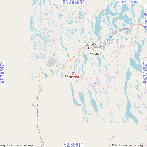
Fermont GPS coordinates[2]
52° 47' 0.42" North, 67° 4' 55.344" West
| Map corner | latitude | longitude |
|---|---|---|
| Upper-left | 53.20665°, | -67.78517° |
| Center: | 52.78345°, | -67.08204° |
| Lower-right: | 52.3561°, | -66.37892° |
| Map W x H: | 94.6×94.6 km | = 58.8×58.8mi |
| max Lat: | 73.03752° ⇑11.5% North |
| Fermont: | 52.78345° |
| min Lat: | ⇓88.5% South 42.05009° |
| min Long | Fermont | max Long |
| -139.43328° | -67.08204° | -52.70931° |
| W 85.9%⇐ | ⇒14.1% E |
Elevation
Elevation of Fermont is 633 m = 2077 ft, and this is 378.6 m = 1242 ft above average elevation for this country.
| Max E: |
1518 m = 4980 ft | 11.8% |
| Fermont | 633 m 2077 ft | |
| Avg. | 254.4 m = 835 ft | |
Min E: |
-2 m = -7 ft | 88.2% |
See also: Canada elevation on elevation.city.
Geographical zone
Fermont is located in North temperate zone (between Tropic of Cancer and the Arctic Circle). Distance of this North polar circle is 1532.2 km =952.1 mi to North.| Distance of | km | miles | from Fermont |
|---|---|---|---|
| North Pole | 4138.1 | 2571.3 | to North |
| Arctic Circle | 1532.2 | 952.1 | to North |
| Tropic Cancer | 3263.1 | 2027.6 | to South |
| Equator | 5869 | 3646.8 | to South |


Nearby cities:
13 places around Fermont: (largest is in red/bold)
• Baie-Comeau
403.5 km =250.7 mi,  190°
190°
• Cap-Chat
410.5 km =255.1 mi,  176°
176°
• Churchill Falls
221.1 km =137.4 mi,  67°
67°
• Chute-aux-Outardes
418 km =259.7 mi, 192°
• Godefroy
133.5 km =83 mi,  210°
210°
• Hauterive
407.3 km =253.1 mi, 191°
• Labrador City
21.4 km =13.3 mi,  32°
32°
• Maliotenam
292.7 km =181.9 mi,  167°
167°
• Matane
440.8 km =273.9 mi, 184°
• Port-Cartier
306.1 km =190.2 mi, 177°
• Saint-Alexandre
307 km =190.8 mi, 177°
• Sainte-Anne-des-Monts
409 km =254.1 mi, 174°
• Sept-Îles
291.3 km =181 mi, 170°
Sources, notices
• [Note1] Compared only with cities in Canada existing in our database
• [Src1] Map data: © OpenStreetMap contributors (CC-BY-SA)
• [Src2] Other city data from geonames.org with taken over terms of usage.
• [Src3] Geographical zone / Annual Mean Temperature by Robert A. Rohde @ Wikipedia
