Courtenay geodata
Courtenay (British Columbia) is a populated place; located in Canada in America/Vancouver (GMT-7) time zone. With population of 32,793 people, there are 138 cities with bigger population in this country. Compared to other cities in Canada, 72.4% of cities are located further ↓South; 97.8% of cities are located further →East and 91.2% of cities have higher elevation than Courtenay. Note1
Administrative division(s):
- Level 1: British Columbia
- Level 2: Comox Valley Regional District
- Level 3: Courtenay


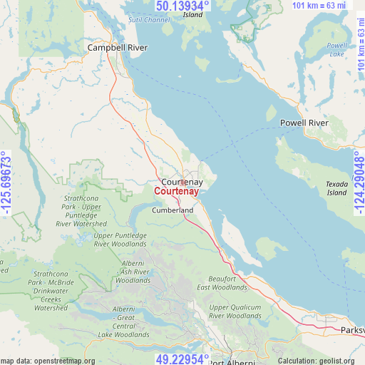
Courtenay GPS coordinates[2]
49° 41' 11.652" North, 124° 59' 36.96" West
| Map corner | latitude | longitude |
|---|---|---|
| Upper-left | 50.13934°, | -125.69673° |
| Center: | 49.68657°, | -124.9936° |
| Lower-right: | 49.22954°, | -124.29048° |
| Map W x H: | 101.2×101.2 km | = 62.9×62.9mi |
| max Lat: | 73.03752° ⇑27.6% North |
| Courtenay: | 49.68657° |
| min Lat: | ⇓72.4% South 42.05009° |
| min Long | Courtenay | max Long |
| -139.43328° | -124.9936° | -52.70931° |
| W 2.2%⇐ | ⇒97.8% E |
Elevation
Elevation of Courtenay is 13 m = 43 ft, and this is 241.4 m = 792 ft below average elevation for this country.
| Max E: |
1518 m = 4980 ft | 91.2% |
| Avg. | 254.4 m = 835 ft | |
| Courtenay | 13 m = 43 ft | |
Min E: |
-2 m = -7 ft | 8.8% |
See also: Canada elevation on elevation.city.
Geographical zone
Courtenay is located in North temperate zone (between Tropic of Cancer and the Arctic Circle). Distance of this North polar circle is 1876.5 km =1166 mi to North.| Distance of | km | miles | from Courtenay |
|---|---|---|---|
| North Pole | 4482.4 | 2785.2 | to North |
| Arctic Circle | 1876.5 | 1166 | to North |
| Tropic Cancer | 2918.7 | 1813.6 | to South |
| Equator | 5524.6 | 3432.8 | to South |


Nearby cities:
15 places around Courtenay: (largest is in red/bold)
• Campbell River
40.8 km =25.4 mi,  333°
333°
• Coombs
59.8 km =37.2 mi,  136°
136°
• Cumberland
8.4 km =5.2 mi,  201°
201°
• Dashwood
49.4 km =30.7 mi, 136°
• Denman Island
21.2 km =13.2 mi, 143°
• Denman Island Trust Area
20.5 km =12.7 mi, 136°
• Englishman River South
68.3 km =42.4 mi,  131°
131°
• French Creek
60 km =37.3 mi, 129°
• Hornby Island
28.8 km =17.9 mi, 125°
• Parksville
63.7 km =39.6 mi, 129°
• Port Alberni
51.4 km =31.9 mi,  164°
164°
• Powell River
37.5 km =23.3 mi,  64°
64°
• Puntledge
5.3 km =3.3 mi,  238°
238°
• Royston
5.5 km =3.4 mi, 142°
• South Pender Harbour
70.1 km =43.6 mi,  95°
95°
Sources, notices
• [Note1] Compared only with cities in Canada existing in our database
• [Src1] Map data: © OpenStreetMap contributors (CC-BY-SA)
• [Src2] Other city data from geonames.org with taken over terms of usage.
• [Src3] Geographical zone / Annual Mean Temperature by Robert A. Rohde @ Wikipedia
