Puntledge geodata
Puntledge (British Columbia) is a populated locality; located in Canada in America/Vancouver (GMT-7) time zone. With population of 1,387 people, there are 890 cities with bigger population in this country. Compared to other cities in Canada, 71.9% of cities are located further ↓South; 98% of cities are located further →East and 58.8% of cities have higher elevation than Puntledge. Note1


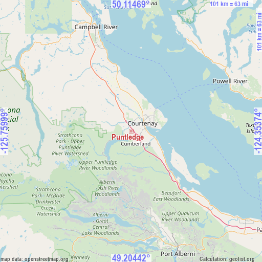
Puntledge GPS coordinates[2]
49° 39' 42.048" North, 125° 3' 24.696" West
| Map corner | latitude | longitude |
|---|---|---|
| Upper-left | 50.11469°, | -125.75999° |
| Center: | 49.66168°, | -125.05686° |
| Lower-right: | 49.20442°, | -124.35374° |
| Map W x H: | 101.2×101.2 km | = 62.9×62.9mi |
| max Lat: | 73.03752° ⇑28.1% North |
| Puntledge: | 49.66168° |
| min Lat: | ⇓71.9% South 42.05009° |
| min Long | Puntledge | max Long |
| -139.43328° | -125.05686° | -52.70931° |
| W 2%⇐ | ⇒98% E |
Elevation
Elevation of Puntledge is 108 m = 354 ft, and this is 146.4 m = 480 ft below average elevation for this country.
| Max E: |
1518 m = 4980 ft | 58.8% |
| Avg. | 254.4 m = 835 ft | |
| Puntledge | 108 m = 354 ft | |
Min E: |
-2 m = -7 ft | 41.2% |
See also: Canada elevation on elevation.city.
Geographical zone
Puntledge is located in North temperate zone (between Tropic of Cancer and the Arctic Circle). Distance of this North polar circle is 1879.3 km =1167.7 mi to North.| Distance of | km | miles | from Puntledge |
|---|---|---|---|
| North Pole | 4485.2 | 2787 | to North |
| Arctic Circle | 1879.3 | 1167.7 | to North |
| Tropic Cancer | 2915.9 | 1811.9 | to South |
| Equator | 5521.9 | 3431.1 | to South |


Nearby cities:
15 places around Puntledge: (largest is in red/bold)
• Campbell River
41.7 km =25.9 mi,  341°
341°
• Coombs
61.2 km =38 mi,  131°
131°
• Courtenay
5.3 km =3.3 mi,  58°
58°
• Cumberland
5.3 km =3.3 mi,  163°
163°
• Dashwood
50.8 km =31.6 mi, 130°
• Denman Island
22.3 km =13.9 mi, 129°
• Denman Island Trust Area
22.2 km =13.8 mi,  123°
123°
• Englishman River South
70.1 km =43.6 mi, 126°
• French Creek
61.9 km =38.5 mi, 125°
• Hornby Island
31.3 km =19.4 mi, 116°
• Parksville
65.7 km =40.8 mi, 125°
• Port Alberni
50.2 km =31.2 mi, 158°
• Powell River
42.8 km =26.6 mi, 63°
• Royston
8.1 km =5 mi,  101°
101°
• South Pender Harbour
74.4 km =46.2 mi,  93°
93°
Sources, notices
• [Note1] Compared only with cities in Canada existing in our database
• [Src1] Map data: © OpenStreetMap contributors (CC-BY-SA)
• [Src2] Other city data from geonames.org with taken over terms of usage.
• [Src3] Geographical zone / Annual Mean Temperature by Robert A. Rohde @ Wikipedia
