Royston geodata
Royston (British Columbia) is a populated place; located in Canada in America/Vancouver (GMT-7) time zone. With population of 1,616 people, there are 834 cities with bigger population in this country. Compared to other cities in Canada, 71.6% of cities are located further ↓South; 97.7% of cities are located further →East and 94.5% of cities have higher elevation than Royston. Note1


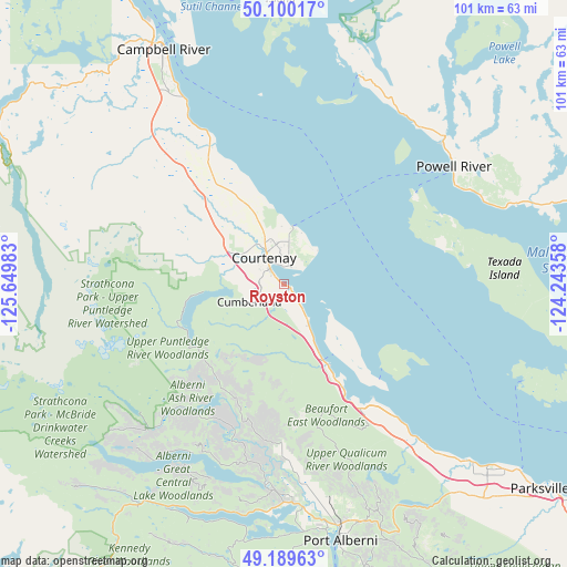
Royston GPS coordinates[2]
49° 38' 49.308" North, 124° 56' 48.12" West
| Map corner | latitude | longitude |
|---|---|---|
| Upper-left | 50.10017°, | -125.64983° |
| Center: | 49.64703°, | -124.9467° |
| Lower-right: | 49.18963°, | -124.24358° |
| Map W x H: | 101.2×101.2 km | = 62.9×62.9mi |
| max Lat: | 73.03752° ⇑28.4% North |
| Royston: | 49.64703° |
| min Lat: | ⇓71.6% South 42.05009° |
| min Long | Royston | max Long |
| -139.43328° | -124.9467° | -52.70931° |
| W 2.3%⇐ | ⇒97.7% E |
Elevation
Elevation of Royston is 9 m = 30 ft, and this is 245.4 m = 805 ft below average elevation for this country.
| Max E: |
1518 m = 4980 ft | 94.5% |
| Avg. | 254.4 m = 835 ft | |
| Royston | 9 m = 30 ft | |
Min E: |
-2 m = -7 ft | 5.5% |
See also: Canada elevation on elevation.city.
Geographical zone
Royston is located in North temperate zone (between Tropic of Cancer and the Arctic Circle). Distance of this North polar circle is 1880.9 km =1168.7 mi to North.| Distance of | km | miles | from Royston |
|---|---|---|---|
| North Pole | 4486.8 | 2788 | to North |
| Arctic Circle | 1880.9 | 1168.7 | to North |
| Tropic Cancer | 2914.3 | 1810.9 | to South |
| Equator | 5520.2 | 3430.1 | to South |


Nearby cities:
15 places around Royston: (largest is in red/bold)
• Campbell River
46.3 km =28.8 mi,  332°
332°
• Coombs
54.3 km =33.7 mi,  135°
135°
• Courtenay
5.5 km =3.4 mi,  322°
322°
• Cumberland
7.3 km =4.5 mi,  242°
242°
• Dashwood
43.9 km =27.3 mi, 135°
• Denman Island
15.7 km =9.8 mi, 144°
• Denman Island Trust Area
15 km =9.3 mi,  134°
134°
• Englishman River South
62.9 km =39.1 mi, 130°
• French Creek
54.6 km =33.9 mi, 128°
• Hornby Island
23.6 km =14.7 mi,  122°
122°
• Parksville
58.3 km =36.2 mi, 128°
• Port Alberni
46.3 km =28.8 mi,  167°
167°
• Powell River
36.7 km =22.8 mi,  55°
55°
• Puntledge
8.1 km =5 mi,  281°
281°
• South Pender Harbour
66.4 km =41.3 mi,  92°
92°
Sources, notices
• [Note1] Compared only with cities in Canada existing in our database
• [Src1] Map data: © OpenStreetMap contributors (CC-BY-SA)
• [Src2] Other city data from geonames.org with taken over terms of usage.
• [Src3] Geographical zone / Annual Mean Temperature by Robert A. Rohde @ Wikipedia
