Powell River geodata
Powell River (British Columbia) is a populated place; located in Canada in America/Vancouver (GMT-7) time zone. With population of 12,779 people, there are 264 cities with bigger population in this country. Compared to other cities in Canada, 74.1% of cities are located further ↓South; 97.3% of cities are located further →East and 75.8% of cities have higher elevation than Powell River. Note1
Administrative division(s):
- Level 1: British Columbia
- Level 2: Powell River Regional District
- Level 3: Powell River


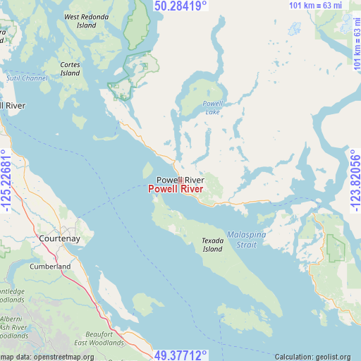
Powell River GPS coordinates[2]
49° 49' 58.008" North, 124° 31' 25.248" West
| Map corner | latitude | longitude |
|---|---|---|
| Upper-left | 50.28419°, | -125.22681° |
| Center: | 49.83278°, | -124.52368° |
| Lower-right: | 49.37712°, | -123.82056° |
| Map W x H: | 100.9×100.9 km | = 62.7×62.7mi |
| max Lat: | 73.03752° ⇑25.9% North |
| Powell River: | 49.83278° |
| min Lat: | ⇓74.1% South 42.05009° |
| min Long | Powell River | max Long |
| -139.43328° | -124.52368° | -52.70931° |
| W 2.7%⇐ | ⇒97.3% E |
Elevation
Elevation of Powell River is 41 m = 135 ft, and this is 213.4 m = 700 ft below average elevation for this country.
| Max E: |
1518 m = 4980 ft | 75.8% |
| Avg. | 254.4 m = 835 ft | |
| Powell River | 41 m = 135 ft | |
Min E: |
-2 m = -7 ft | 24.2% |
See also: Canada elevation on elevation.city.
Geographical zone
Powell River is located in North temperate zone (between Tropic of Cancer and the Arctic Circle). Distance of this North polar circle is 1860.3 km =1155.9 mi to North.| Distance of | km | miles | from Powell River |
|---|---|---|---|
| North Pole | 4466.2 | 2775.2 | to North |
| Arctic Circle | 1860.3 | 1155.9 | to North |
| Tropic Cancer | 2935 | 1823.7 | to South |
| Equator | 5540.9 | 3443 | to South |


Nearby cities:
15 places around Powell River: (largest is in red/bold)
• Campbell River
55.5 km =34.5 mi,  291°
291°
• Coombs
59.8 km =37.2 mi,  172°
172°
• Courtenay
37.5 km =23.3 mi,  244°
244°
• Cumberland
44 km =27.3 mi, 236°
• Dashwood
51.9 km =32.2 mi,  179°
179°
• Denman Island
39.6 km =24.6 mi,  212°
212°
• Denman Island Trust Area
37 km =23 mi, 212°
• Englishman River South
63.7 km =39.6 mi,  164°
164°
• French Creek
56 km =34.8 mi, 167°
• Hornby Island
34.8 km =21.6 mi,  197°
197°
• Parksville
59 km =36.7 mi, 165°
• Puntledge
42.8 km =26.6 mi, 243°
• Royston
36.7 km =22.8 mi, 235°
• South Pender Harbour
42.8 km =26.6 mi,  123°
123°
• Welcome Beach
60.1 km =37.3 mi,  130°
130°
Sources, notices
• [Note1] Compared only with cities in Canada existing in our database
• [Src1] Map data: © OpenStreetMap contributors (CC-BY-SA)
• [Src2] Other city data from geonames.org with taken over terms of usage.
• [Src3] Geographical zone / Annual Mean Temperature by Robert A. Rohde @ Wikipedia
