Valleyview geodata
Valleyview (Alberta) is a populated place; located in Canada in America/Edmonton (GMT-6) time zone. With population of 1,951 people, there are 759 cities with bigger population in this country. Compared to other cities in Canada, 95.1% of cities are located further ↓South; 85.1% of cities are located further →East and 91.4% of cities have lower elevation than Valleyview. Note1


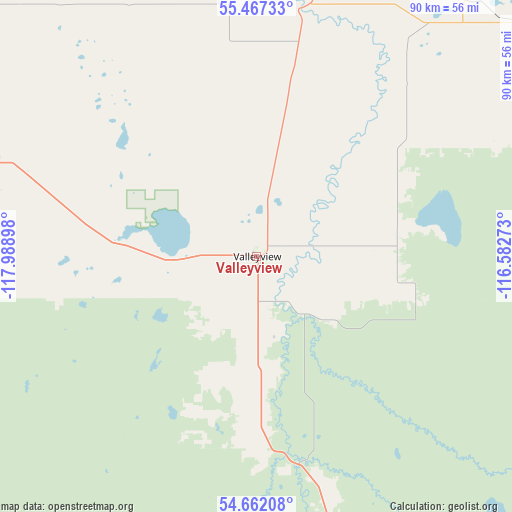
Valleyview GPS coordinates[2]
55° 4' 0.228" North, 117° 17' 9.06" West
| Map corner | latitude | longitude |
|---|---|---|
| Upper-left | 55.46733°, | -117.98898° |
| Center: | 55.06673°, | -117.28585° |
| Lower-right: | 54.66208°, | -116.58273° |
| Map W x H: | 89.5×89.5 km | = 55.6×55.6mi |
| max Lat: | 73.03752° ⇑4.9% North |
| Valleyview: | 55.06673° |
| min Lat: | ⇓95.1% South 42.05009° |
| min Long | Valleyview | max Long |
| -139.43328° | -117.28585° | -52.70931° |
| W 14.9%⇐ | ⇒85.1% E |
Elevation
Elevation of Valleyview is 692 m = 2270 ft, and this is 437.6 m = 1436 ft above average elevation for this country.
| Max E: |
1518 m = 4980 ft | 8.6% |
| Valleyview | 692 m 2270 ft | |
| Avg. | 254.4 m = 835 ft | |
Min E: |
-2 m = -7 ft | 91.4% |
See also: Canada elevation on elevation.city.
Geographical zone
Valleyview is located in North temperate zone (between Tropic of Cancer and the Arctic Circle). Distance of this North polar circle is 1278.3 km =794.3 mi to North.| Distance of | km | miles | from Valleyview |
|---|---|---|---|
| North Pole | 3884.2 | 2413.5 | to North |
| Arctic Circle | 1278.3 | 794.3 | to North |
| Tropic Cancer | 3516.9 | 2185.3 | to South |
| Equator | 6122.8 | 3804.5 | to South |


Nearby cities:
15 places around Valleyview: (largest is in red/bold)
• Beaverlodge
137.7 km =85.6 mi,  276°
276°
• Fairview
130.9 km =81.3 mi,  328°
328°
• Falher
74.3 km =46.2 mi,  4°
4°
• Fox Creek
80.4 km =50 mi,  157°
157°
• Grande Prairie
97.1 km =60.3 mi, 276°
• Grimshaw
125.7 km =78.1 mi,  350°
350°
• High Prairie
65.1 km =40.5 mi,  51°
51°
• Peace River
130.1 km =80.8 mi,  359°
359°
• Sexsmith
100.3 km =62.3 mi,  288°
288°
• Spirit River
126.2 km =78.4 mi,  309°
309°
• Swan Hills
126.6 km =78.7 mi,  107°
107°
• Wedgewood
94.8 km =58.9 mi,  273°
273°
• Wembley
118 km =73.3 mi, 274°
• Westlake
98 km =60.9 mi, 280°
• Whitecourt
144.9 km =90 mi,  134°
134°
Sources, notices
• [Note1] Compared only with cities in Canada existing in our database
• [Src1] Map data: © OpenStreetMap contributors (CC-BY-SA)
• [Src2] Other city data from geonames.org with taken over terms of usage.
• [Src3] Geographical zone / Annual Mean Temperature by Robert A. Rohde @ Wikipedia
