Perth geodata
Perth (Ontario) is a populated place; located in Canada in America/Toronto (GMT-4) time zone. With population of 5,573 people, there are 450 cities with bigger population in this country. Compared to other cities in Canada, 85.4% of cities are located further ↑North; 54.2% of cities are located further ←West and 55.3% of cities have higher elevation than Perth. Note1


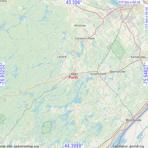
Perth GPS coordinates[2]
44° 54' 0.396" North, 76° 14' 57.804" West
| Map corner | latitude | longitude |
|---|---|---|
| Upper-left | 45.396°, | -76.95252° |
| Center: | 44.90011°, | -76.24939° |
| Lower-right: | 44.3999°, | -75.54627° |
| Map W x H: | 110.8×110.8 km | = 68.8×68.8mi |
| max Lat: | 73.03752° ⇑85.4% North |
| Perth: | 44.90011° |
| min Lat: | ⇓14.6% South 42.05009° |
| min Long | Perth | max Long |
| -139.43328° | -76.24939° | -52.70931° |
| W 54.2%⇐ | ⇒45.8% E |
Elevation
Elevation of Perth is 134 m = 440 ft, and this is 120.4 m = 395 ft below average elevation for this country.
| Max E: |
1518 m = 4980 ft | 55.3% |
| Avg. | 254.4 m = 835 ft | |
| Perth | 134 m = 440 ft | |
Min E: |
-2 m = -7 ft | 44.7% |
See also: Canada elevation on elevation.city.
Geographical zone
Perth is located in North temperate zone (between Tropic of Cancer and the Arctic Circle). Distance of this Northern Tropic circle is 2386.5 km =1482.9 mi to South.| Distance of | km | miles | from Perth |
|---|---|---|---|
| North Pole | 5014.6 | 3115.9 | to North |
| Arctic Circle | 2408.7 | 1496.7 | to North |
| Tropic Cancer | 2386.5 | 1482.9 | to South |
| Equator | 4992.4 | 3102.1 | to South |


Nearby cities:
15 places around Perth: (largest is in red/bold)
• Arnprior
59.8 km =37.2 mi,  352°
352°
• Athens
38 km =23.6 mi,  141°
141°
• Bells Corners
56.7 km =35.2 mi,  35°
35°
• Brockville
56.1 km =34.9 mi,  127°
127°
• Carleton Place
27.1 km =16.8 mi,  16°
16°
• Constance Bay
68 km =42.3 mi,  11°
11°
• Gananoque
63.4 km =39.4 mi,  174°
174°
• Kanata
51.6 km =32.1 mi,  30°
30°
• Nepean
64.2 km =39.9 mi, 38°
• Osgoode
58.2 km =36.2 mi,  61°
61°
• Ottawa
71.4 km =44.4 mi, 37°
• Prescott
61.3 km =38.1 mi,  109°
109°
• Richmond
45.4 km =28.2 mi,  46°
46°
• Smiths Falls
17.8 km =11.1 mi,  88°
88°
• le Plateau
69.9 km =43.4 mi, 31°
Sources, notices
• [Note1] Compared only with cities in Canada existing in our database
• [Src1] Map data: © OpenStreetMap contributors (CC-BY-SA)
• [Src2] Other city data from geonames.org with taken over terms of usage.
• [Src3] Geographical zone / Annual Mean Temperature by Robert A. Rohde @ Wikipedia
