Smiths Falls geodata
Smiths Falls (Ontario) is a populated place; located in Canada in America/Toronto (GMT-4) time zone. With population of 8,885 people, there are 340 cities with bigger population in this country. Compared to other cities in Canada, 85.3% of cities are located further ↑North; 54.6% of cities are located further ←West and 55.8% of cities have higher elevation than Smiths Falls. Note1


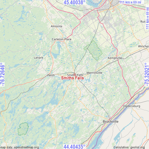
Smiths Falls GPS coordinates[2]
44° 54' 16.272" North, 76° 1' 23.988" West
| Map corner | latitude | longitude |
|---|---|---|
| Upper-left | 45.40038°, | -76.72646° |
| Center: | 44.90452°, | -76.02333° |
| Lower-right: | 44.40435°, | -75.32021° |
| Map W x H: | 110.7×110.7 km | = 68.8×68.8mi |
| max Lat: | 73.03752° ⇑85.3% North |
| Smiths Falls: | 44.90452° |
| min Lat: | ⇓14.7% South 42.05009° |
| min Long | Smiths Falls | max Long |
| -139.43328° | -76.02333° | -52.70931° |
| W 54.6%⇐ | ⇒45.4% E |
Elevation
Elevation of Smiths Falls is 131 m = 430 ft, and this is 123.4 m = 405 ft below average elevation for this country.
| Max E: |
1518 m = 4980 ft | 55.8% |
| Avg. | 254.4 m = 835 ft | |
| Smiths Falls | 131 m = 430 ft | |
Min E: |
-2 m = -7 ft | 44.2% |
See also: Canada elevation on elevation.city.
Geographical zone
Smiths Falls is located in North temperate zone (between Tropic of Cancer and the Arctic Circle). Distance of this Northern Tropic circle is 2387 km =1483.2 mi to South.| Distance of | km | miles | from Smiths Falls |
|---|---|---|---|
| North Pole | 5014.1 | 3115.6 | to North |
| Arctic Circle | 2408.3 | 1496.4 | to North |
| Tropic Cancer | 2387 | 1483.2 | to South |
| Equator | 4992.9 | 3102.4 | to South |


Nearby cities:
15 places around Smiths Falls: (largest is in red/bold)
• Arnprior
64.1 km =39.8 mi,  336°
336°
• Athens
30.7 km =19.1 mi,  169°
169°
• Bells Corners
48.2 km =30 mi,  18°
18°
• Brockville
43.8 km =27.2 mi,  142°
142°
• Carleton Place
27.3 km =17 mi, 338°
• Kanata
44.8 km =27.8 mi,  10°
10°
• Metcalfe
57 km =35.4 mi,  50°
50°
• Nepean
54.5 km =33.9 mi, 24°
• Osgoode
43.1 km =26.8 mi, 50°
• Ottawa
61.8 km =38.4 mi, 24°
• Perth
17.8 km =11.1 mi,  268°
268°
• Prescott
45.1 km =28 mi,  117°
117°
• Richmond
34.4 km =21.4 mi,  25°
25°
• Winchester
56.6 km =35.2 mi,  69°
69°
• le Plateau
62 km =38.5 mi, 17°
Sources, notices
• [Note1] Compared only with cities in Canada existing in our database
• [Src1] Map data: © OpenStreetMap contributors (CC-BY-SA)
• [Src2] Other city data from geonames.org with taken over terms of usage.
• [Src3] Geographical zone / Annual Mean Temperature by Robert A. Rohde @ Wikipedia
