Hanna geodata
Hanna (Alberta) is a populated place; located in Canada in America/Edmonton (GMT-6) time zone. With population of 3,140 people, there are 599 cities with bigger population in this country. Compared to other cities in Canada, 84.8% of cities are located further ↓South; 76.4% of cities are located further →East and 95% of cities have lower elevation than Hanna. Note1


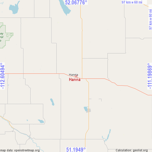
Hanna GPS coordinates[2]
51° 38' 0.348" North, 111° 54' 6.516" West
| Map corner | latitude | longitude |
|---|---|---|
| Upper-left | 52.06776°, | -112.60494° |
| Center: | 51.63343°, | -111.90181° |
| Lower-right: | 51.1949°, | -111.19869° |
| Map W x H: | 97.1×97 km | = 60.3×60.3mi |
| max Lat: | 73.03752° ⇑15.2% North |
| Hanna: | 51.63343° |
| min Lat: | ⇓84.8% South 42.05009° |
| min Long | Hanna | max Long |
| -139.43328° | -111.90181° | -52.70931° |
| W 23.6%⇐ | ⇒76.4% E |
Elevation
Elevation of Hanna is 826 m = 2710 ft, and this is 571.6 m = 1875 ft above average elevation for this country.
| Max E: |
1518 m = 4980 ft | 5% |
| Hanna | 826 m 2710 ft | |
| Avg. | 254.4 m = 835 ft | |
Min E: |
-2 m = -7 ft | 95% |
See also: Canada elevation on elevation.city.
Geographical zone
Hanna is located in North temperate zone (between Tropic of Cancer and the Arctic Circle). Distance of this North polar circle is 1660.1 km =1031.5 mi to North.| Distance of | km | miles | from Hanna |
|---|---|---|---|
| North Pole | 4266 | 2650.8 | to North |
| Arctic Circle | 1660.1 | 1031.5 | to North |
| Tropic Cancer | 3135.2 | 1948.1 | to South |
| Equator | 5741.1 | 3567.4 | to South |


Nearby cities:
15 places around Hanna: (largest is in red/bold)
• Bassano
102.4 km =63.6 mi,  202°
202°
• Brooks
116.8 km =72.6 mi,  179°
179°
• Carstairs
152.1 km =94.5 mi,  267°
267°
• Chestermere
148.9 km =92.5 mi,  243°
243°
• Crossfield
149.2 km =92.7 mi,  261°
261°
• Irricana
122.8 km =76.3 mi,  253°
253°
• Killam
127.9 km =79.5 mi,  1°
1°
• Penhold
146 km =90.7 mi,  292°
292°
• Provost
137.3 km =85.3 mi,  54°
54°
• Red Deer
148 km =92 mi,  298°
298°
• Springbrook
148.6 km =92.3 mi, 294°
• Stettler
94.4 km =58.7 mi,  323°
323°
• Strathmore
121.7 km =75.6 mi, 237°
• Three Hills
94.6 km =58.8 mi, 274°
• Wainwright
151.5 km =94.1 mi,  28°
28°
Sources, notices
• [Note1] Compared only with cities in Canada existing in our database
• [Src1] Map data: © OpenStreetMap contributors (CC-BY-SA)
• [Src2] Other city data from geonames.org with taken over terms of usage.
• [Src3] Geographical zone / Annual Mean Temperature by Robert A. Rohde @ Wikipedia
