Humboldt geodata
Humboldt (Saskatchewan) is a populated place; located in Canada in America/Regina (GMT-6) time zone. With population of 4,822 people, there are 482 cities with bigger population in this country. Compared to other cities in Canada, 86.8% of cities are located further ↓South; 72.2% of cities are located further →East and 85% of cities have lower elevation than Humboldt. Note1


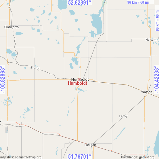
Humboldt GPS coordinates[2]
52° 12' 0.18" North, 105° 7' 31.8" West
| Map corner | latitude | longitude |
|---|---|---|
| Upper-left | 52.62891°, | -105.82863° |
| Center: | 52.20005°, | -105.1255° |
| Lower-right: | 51.76701°, | -104.42238° |
| Map W x H: | 95.8×95.8 km | = 59.5×59.5mi |
| max Lat: | 73.03752° ⇑13.2% North |
| Humboldt: | 52.20005° |
| min Lat: | ⇓86.8% South 42.05009° |
| min Long | Humboldt | max Long |
| -139.43328° | -105.1255° | -52.70931° |
| W 27.8%⇐ | ⇒72.2% E |
Elevation
Elevation of Humboldt is 568 m = 1864 ft, and this is 313.6 m = 1029 ft above average elevation for this country.
| Max E: |
1518 m = 4980 ft | 15% |
| Humboldt | 568 m 1864 ft | |
| Avg. | 254.4 m = 835 ft | |
Min E: |
-2 m = -7 ft | 85% |
See also: Canada elevation on elevation.city.
Geographical zone
Humboldt is located in North temperate zone (between Tropic of Cancer and the Arctic Circle). Distance of this North polar circle is 1597.1 km =992.4 mi to North.| Distance of | km | miles | from Humboldt |
|---|---|---|---|
| North Pole | 4203 | 2611.6 | to North |
| Arctic Circle | 1597.1 | 992.4 | to North |
| Tropic Cancer | 3198.2 | 1987.3 | to South |
| Equator | 5804.1 | 3606.5 | to South |


Nearby cities:
15 places around Humboldt: (largest is in red/bold)
• Dalmeny
112.7 km =70 mi,  277°
277°
• Davidson
119.4 km =74.2 mi,  209°
209°
• Foam Lake
125.1 km =77.7 mi,  119°
119°
• Kelvington
108.5 km =67.4 mi,  91°
91°
• Lanigan
39.4 km =24.5 mi,  170°
170°
• Martensville
105.4 km =65.5 mi, 275°
• Melfort
81.7 km =50.8 mi,  24°
24°
• Prince Albert
119.3 km =74.1 mi,  338°
338°
• Rosthern
97 km =60.3 mi,  302°
302°
• Saskatoon
105.5 km =65.6 mi,  265°
265°
• Tisdale
102.5 km =63.7 mi,  45°
45°
• Wadena
94.7 km =58.8 mi,  107°
107°
• Warman
99 km =61.5 mi, 277°
• Watrous
63.8 km =39.6 mi,  201°
201°
• Wynyard
80.5 km =50 mi,  126°
126°
Sources, notices
• [Note1] Compared only with cities in Canada existing in our database
• [Src1] Map data: © OpenStreetMap contributors (CC-BY-SA)
• [Src2] Other city data from geonames.org with taken over terms of usage.
• [Src3] Geographical zone / Annual Mean Temperature by Robert A. Rohde @ Wikipedia
