Kelvington geodata
Kelvington (Saskatchewan) is a populated place; located in Canada in America/Regina (GMT-6) time zone. With population of 941 people, there are 1068 cities with bigger population in this country. Compared to other cities in Canada, 86.5% of cities are located further ↓South; 70.9% of cities are located further →East and 86% of cities have lower elevation than Kelvington. Note1


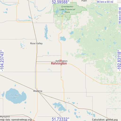
Kelvington GPS coordinates[2]
52° 10' 0.084" North, 103° 32' 3.48" West
| Map corner | latitude | longitude |
|---|---|---|
| Upper-left | 52.59588°, | -104.23743° |
| Center: | 52.16669°, | -103.5343° |
| Lower-right: | 51.73332°, | -102.83118° |
| Map W x H: | 95.9×95.9 km | = 59.6×59.6mi |
| max Lat: | 73.03752° ⇑13.5% North |
| Kelvington: | 52.16669° |
| min Lat: | ⇓86.5% South 42.05009° |
| min Long | Kelvington | max Long |
| -139.43328° | -103.5343° | -52.70931° |
| W 29.1%⇐ | ⇒70.9% E |
Elevation
Elevation of Kelvington is 586 m = 1923 ft, and this is 331.6 m = 1088 ft above average elevation for this country.
| Max E: |
1518 m = 4980 ft | 14% |
| Kelvington | 586 m 1923 ft | |
| Avg. | 254.4 m = 835 ft | |
Min E: |
-2 m = -7 ft | 86% |
See also: Canada elevation on elevation.city.
Geographical zone
Kelvington is located in North temperate zone (between Tropic of Cancer and the Arctic Circle). Distance of this North polar circle is 1600.8 km =994.7 mi to North.| Distance of | km | miles | from Kelvington |
|---|---|---|---|
| North Pole | 4206.7 | 2613.9 | to North |
| Arctic Circle | 1600.8 | 994.7 | to North |
| Tropic Cancer | 3194.5 | 1985 | to South |
| Equator | 5800.4 | 3604.2 | to South |


Nearby cities:
15 places around Kelvington: (largest is in red/bold)
• Canora
96 km =59.7 mi,  128°
128°
• Carrot River
124.2 km =77.2 mi,  358°
358°
• Foam Lake
57.4 km =35.7 mi,  180°
180°
• Hudson Bay
108.8 km =67.6 mi,  45°
45°
• Humboldt
108.5 km =67.4 mi,  271°
271°
• Kamsack
130.5 km =81.1 mi,  120°
120°
• Lanigan
108.5 km =67.4 mi,  251°
251°
• Melfort
106.9 km =66.4 mi,  316°
316°
• Nipawin
137.1 km =85.2 mi,  346°
346°
• Preeceville
64 km =39.8 mi,  112°
112°
• Tisdale
83.6 km =51.9 mi,  335°
335°
• Wadena
30.2 km =18.8 mi,  217°
217°
• Watrous
143.8 km =89.4 mi, 247°
• Wynyard
62.9 km =39.1 mi,  225°
225°
• Yorkton
128.7 km =80 mi,  145°
145°
Sources, notices
• [Note1] Compared only with cities in Canada existing in our database
• [Src1] Map data: © OpenStreetMap contributors (CC-BY-SA)
• [Src2] Other city data from geonames.org with taken over terms of usage.
• [Src3] Geographical zone / Annual Mean Temperature by Robert A. Rohde @ Wikipedia
