Melfort geodata
Melfort (Saskatchewan) is a populated place; located in Canada in America/Regina (GMT-6) time zone. With population of 5,778 people, there are 437 cities with bigger population in this country. Compared to other cities in Canada, 88.8% of cities are located further ↓South; 71.8% of cities are located further →East and 80.2% of cities have lower elevation than Melfort. Note1


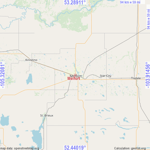
Melfort GPS coordinates[2]
52° 52' 0.228" North, 104° 37' 3.648" West
| Map corner | latitude | longitude |
|---|---|---|
| Upper-left | 53.28911°, | -105.32081° |
| Center: | 52.86673°, | -104.61768° |
| Lower-right: | 52.44019°, | -103.91456° |
| Map W x H: | 94.4×94.4 km | = 58.7×58.7mi |
| max Lat: | 73.03752° ⇑11.2% North |
| Melfort: | 52.86673° |
| min Lat: | ⇓88.8% South 42.05009° |
| min Long | Melfort | max Long |
| -139.43328° | -104.61768° | -52.70931° |
| W 28.2%⇐ | ⇒71.8% E |
Elevation
Elevation of Melfort is 457 m = 1499 ft, and this is 202.6 m = 665 ft above average elevation for this country.
| Max E: |
1518 m = 4980 ft | 19.8% |
| Melfort | 457 m 1499 ft | |
| Avg. | 254.4 m = 835 ft | |
Min E: |
-2 m = -7 ft | 80.2% |
See also: Canada elevation on elevation.city.
Geographical zone
Melfort is located in North temperate zone (between Tropic of Cancer and the Arctic Circle). Distance of this North polar circle is 1522.9 km =946.3 mi to North.| Distance of | km | miles | from Melfort |
|---|---|---|---|
| North Pole | 4128.8 | 2565.5 | to North |
| Arctic Circle | 1522.9 | 946.3 | to North |
| Tropic Cancer | 3272.3 | 2033.3 | to South |
| Equator | 5878.2 | 3652.5 | to South |


Nearby cities:
15 places around Melfort: (largest is in red/bold)
• Carrot River
83.1 km =51.6 mi,  56°
56°
• Hudson Bay
149.9 km =93.1 mi,  90°
90°
• Humboldt
81.7 km =50.8 mi,  204°
204°
• Kelvington
106.9 km =66.4 mi,  136°
136°
• Lanigan
116.5 km =72.4 mi,  194°
194°
• Martensville
153 km =95.1 mi,  244°
244°
• Nipawin
69.2 km =43 mi,  36°
36°
• Prince Albert
85.4 km =53.1 mi,  295°
295°
• Rosthern
117.6 km =73.1 mi,  259°
259°
• Shellbrook
125.4 km =77.9 mi,  288°
288°
• Tisdale
38.1 km =23.7 mi, 92°
• Wadena
116 km =72.1 mi,  151°
151°
• Warman
145.2 km =90.2 mi,  245°
245°
• Watrous
145.4 km =90.3 mi, 203°
• Wynyard
125.8 km =78.2 mi,  166°
166°
Sources, notices
• [Note1] Compared only with cities in Canada existing in our database
• [Src1] Map data: © OpenStreetMap contributors (CC-BY-SA)
• [Src2] Other city data from geonames.org with taken over terms of usage.
• [Src3] Geographical zone / Annual Mean Temperature by Robert A. Rohde @ Wikipedia
