Laurentides geodata
Laurentides (Quebec) is a populated place; located in Canada in America/Toronto (GMT-4) time zone. With population of 12,710 people, there are 267 cities with bigger population in this country. Compared to other cities in Canada, 51.3% of cities are located further ↑North; 75.6% of cities are located further ←West and 61.2% of cities have lower elevation than Laurentides. Note1


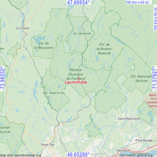
Laurentides GPS coordinates[2]
47° 8' 0.096" North, 72° 16' 56.604" West
| Map corner | latitude | longitude |
|---|---|---|
| Upper-left | 47.60954°, | -72.98552° |
| Center: | 47.13336°, | -72.28239° |
| Lower-right: | 46.65288°, | -71.57927° |
| Map W x H: | 106.4×106.4 km | = 66.1×66.1mi |
| max Lat: | 73.03752° ⇑51.3% North |
| Laurentides: | 47.13336° |
| min Lat: | ⇓48.7% South 42.05009° |
| min Long | Laurentides | max Long |
| -139.43328° | -72.28239° | -52.70931° |
| W 75.6%⇐ | ⇒24.4% E |
Elevation
Elevation of Laurentides is 239 m = 784 ft, and this is 15.4 m = 51 ft below average elevation for this country.
| Max E: |
1518 m = 4980 ft | 38.8% |
| Avg. | 254.4 m = 835 ft | |
| Laurentides | 239 m = 784 ft | |
Min E: |
-2 m = -7 ft | 61.2% |
See also: Canada elevation on elevation.city.
Geographical zone
Laurentides is located in North temperate zone (between Tropic of Cancer and the Arctic Circle). Distance of this North polar circle is 2160.4 km =1342.4 mi to North.| Distance of | km | miles | from Laurentides |
|---|---|---|---|
| North Pole | 4766.3 | 2961.6 | to North |
| Arctic Circle | 2160.4 | 1342.4 | to North |
| Tropic Cancer | 2634.8 | 1637.2 | to South |
| Equator | 5240.7 | 3256.4 | to South |


Nearby cities:
15 places around Laurentides: (largest is in red/bold)
• Cap-Santé
63.6 km =39.5 mi,  143°
143°
• Donnacona
65.8 km =40.9 mi, 139°
• Fossambault-sur-le-Lac
58.1 km =36.1 mi,  119°
119°
• Hérouxville
58.1 km =36.1 mi,  206°
206°
• La Tuque
50.4 km =31.3 mi,  311°
311°
• Lotbinière
63.3 km =39.3 mi,  155°
155°
• Neuville
71.9 km =44.7 mi,  132°
132°
• Pont-Rouge
61.3 km =38.1 mi, 133°
• Portneuf
57.5 km =35.7 mi,  148°
148°
• Saint-Marc-des-Carrières
53.1 km =33 mi, 160°
• Saint-Pierre-les-Becquets
70.7 km =43.9 mi,  174°
174°
• Saint-Tite
49.4 km =30.7 mi, 205°
• Sainte Catherine de la Jacques Cartier
59.1 km =36.7 mi, 121°
• Sainte-Thècle
38.9 km =24.2 mi, 205°
• Shannon
64.7 km =40.2 mi, 115°
Sources, notices
• [Note1] Compared only with cities in Canada existing in our database
• [Src1] Map data: © OpenStreetMap contributors (CC-BY-SA)
• [Src2] Other city data from geonames.org with taken over terms of usage.
• [Src3] Geographical zone / Annual Mean Temperature by Robert A. Rohde @ Wikipedia
