La Tuque geodata
La Tuque (Quebec) is a populated place; located in Canada in America/Toronto (GMT-4) time zone. With population of 9,503 people, there are 326 cities with bigger population in this country. Compared to other cities in Canada, 50% of cities are located further ↓South; 73.3% of cities are located further ←West and 50.9% of cities have higher elevation than La Tuque. Note1


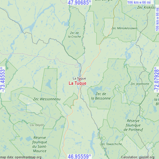
La Tuque GPS coordinates[2]
47° 26' 0.132" North, 72° 46' 56.64" West
| Map corner | latitude | longitude |
|---|---|---|
| Upper-left | 47.90685°, | -73.48553° |
| Center: | 47.43337°, | -72.7824° |
| Lower-right: | 46.95559°, | -72.07928° |
| Map W x H: | 105.8×105.8 km | = 65.7×65.7mi |
| max Lat: | 73.03752° ⇑50% North |
| La Tuque: | 47.43337° |
| min Lat: | ⇓50% South 42.05009° |
| min Long | La Tuque | max Long |
| -139.43328° | -72.7824° | -52.70931° |
| W 73.3%⇐ | ⇒26.7% E |
Elevation
Elevation of La Tuque is 165 m = 541 ft, and this is 89.4 m = 293 ft below average elevation for this country.
| Max E: |
1518 m = 4980 ft | 50.9% |
| Avg. | 254.4 m = 835 ft | |
| La Tuque | 165 m = 541 ft | |
Min E: |
-2 m = -7 ft | 49.1% |
See also: Canada elevation on elevation.city.
Geographical zone
La Tuque is located in North temperate zone (between Tropic of Cancer and the Arctic Circle). Distance of this North polar circle is 2127.1 km =1321.7 mi to North.| Distance of | km | miles | from La Tuque |
|---|---|---|---|
| North Pole | 4733 | 2940.9 | to North |
| Arctic Circle | 2127.1 | 1321.7 | to North |
| Tropic Cancer | 2668.2 | 1657.9 | to South |
| Equator | 5274.1 | 3277.2 | to South |


Nearby cities:
15 places around La Tuque: (largest is in red/bold)
• Cap-Santé
113.3 km =70.4 mi,  138°
138°
• Fossambault-sur-le-Lac
107.8 km =67 mi,  125°
125°
• Hérouxville
86.1 km =53.5 mi,  172°
172°
• Laurentides
50.4 km =31.3 mi, 131°
• Lotbinière
111.3 km =69.2 mi, 144°
• Pont-Rouge
111.6 km =69.3 mi, 132°
• Portneuf
106.7 km =66.3 mi, 140°
• Saint-Marc-des-Carrières
100.2 km =62.3 mi,  146°
146°
• Saint-Pierre-les-Becquets
112.8 km =70.1 mi,  156°
156°
• Saint-Tite
79.5 km =49.4 mi, 168°
• Sainte Catherine de la Jacques Cartier
109.1 km =67.8 mi, 126°
• Sainte-Thècle
71.8 km =44.6 mi, 162°
• Shannon
113.9 km =70.8 mi,  122°
122°
• Shawinigan
96.4 km =59.9 mi,  178°
178°
• Weymontachie
90.7 km =56.4 mi,  304°
304°
Sources, notices
• [Note1] Compared only with cities in Canada existing in our database
• [Src1] Map data: © OpenStreetMap contributors (CC-BY-SA)
• [Src2] Other city data from geonames.org with taken over terms of usage.
• [Src3] Geographical zone / Annual Mean Temperature by Robert A. Rohde @ Wikipedia
