Sainte-Thècle geodata
Sainte-Thècle (Quebec) is a populated place; located in Canada in America/Toronto (GMT-4) time zone. With population of 1,333 people, there are 907 cities with bigger population in this country. Compared to other cities in Canada, 52.5% of cities are located further ↑North; 74.8% of cities are located further ←West and 52.8% of cities have higher elevation than Sainte-Thècle. Note1


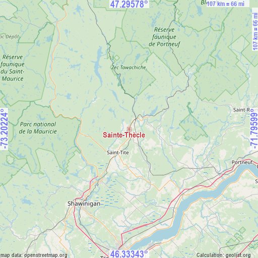
Sainte-Thècle GPS coordinates[2]
46° 49' 0.336" North, 72° 29' 56.796" West
| Map corner | latitude | longitude |
|---|---|---|
| Upper-left | 47.29578°, | -73.20224° |
| Center: | 46.81676°, | -72.49911° |
| Lower-right: | 46.33343°, | -71.79599° |
| Map W x H: | 107×107 km | = 66.5×66.5mi |
| max Lat: | 73.03752° ⇑52.5% North |
| Sainte-Thècle: | 46.81676° |
| min Lat: | ⇓47.5% South 42.05009° |
| min Long | Sainte-Thècle | max Long |
| -139.43328° | -72.49911° | -52.70931° |
| W 74.8%⇐ | ⇒25.2% E |
Elevation
Elevation of Sainte-Thècle is 155 m = 509 ft, and this is 99.4 m = 326 ft below average elevation for this country.
| Max E: |
1518 m = 4980 ft | 52.8% |
| Avg. | 254.4 m = 835 ft | |
| Sainte-Thècle | 155 m = 509 ft | |
Min E: |
-2 m = -7 ft | 47.2% |
See also: Canada elevation on elevation.city.
Geographical zone
Sainte-Thècle is located in North temperate zone (between Tropic of Cancer and the Arctic Circle). Distance of this North polar circle is 2195.6 km =1364.3 mi to North.| Distance of | km | miles | from Sainte-Thècle |
|---|---|---|---|
| North Pole | 4801.5 | 2983.5 | to North |
| Arctic Circle | 2195.6 | 1364.3 | to North |
| Tropic Cancer | 2599.6 | 1615.3 | to South |
| Equator | 5205.5 | 3234.5 | to South |


Nearby cities:
15 places around Sainte-Thècle: (largest is in red/bold)
• Bécancour
53.1 km =33 mi,  174°
174°
• Cap-Santé
56.5 km =35.1 mi,  106°
106°
• Donnacona
61 km =37.9 mi,  104°
104°
• Hérouxville
19.3 km =12 mi,  209°
209°
• Laurentides
38.9 km =24.2 mi,  25°
25°
• Lotbinière
48.6 km =30.2 mi,  117°
117°
• Pont-Rouge
61.6 km =38.3 mi, 96°
• Portneuf
48.5 km =30.1 mi, 106°
• Saint-Marc-des-Carrières
37.4 km =23.2 mi, 113°
• Saint-Pierre-les-Becquets
42 km =26.1 mi,  146°
146°
• Saint-Tite
10.6 km =6.6 mi, 208°
• Sainte-Catherine
55.7 km =34.6 mi,  185°
185°
• Shawinigan
33.7 km =20.9 mi, 214°
• Trois-Rivières
52.6 km =32.7 mi,  184°
184°
• Yamachiche
66.3 km =41.2 mi,  202°
202°
Sources, notices
• [Note1] Compared only with cities in Canada existing in our database
• [Src1] Map data: © OpenStreetMap contributors (CC-BY-SA)
• [Src2] Other city data from geonames.org with taken over terms of usage.
• [Src3] Geographical zone / Annual Mean Temperature by Robert A. Rohde @ Wikipedia
