Metcalfe geodata
Metcalfe (Ontario) is a populated place; located in Canada in America/Toronto (GMT-4) time zone. With population of 1,776 people, there are 797 cities with bigger population in this country. Compared to other cities in Canada, 82.2% of cities are located further ↑North; 56.7% of cities are located further ←West and 62.5% of cities have higher elevation than Metcalfe. Note1


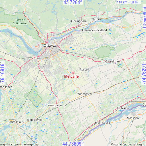
Metcalfe GPS coordinates[2]
45° 14' 0.24" North, 75° 27' 57.708" West
| Map corner | latitude | longitude |
|---|---|---|
| Upper-left | 45.7264°, | -76.16916° |
| Center: | 45.2334°, | -75.46603° |
| Lower-right: | 44.73609°, | -74.76291° |
| Map W x H: | 110.1×110.1 km | = 68.4×68.4mi |
| max Lat: | 73.03752° ⇑82.2% North |
| Metcalfe: | 45.2334° |
| min Lat: | ⇓17.8% South 42.05009° |
| min Long | Metcalfe | max Long |
| -139.43328° | -75.46603° | -52.70931° |
| W 56.7%⇐ | ⇒43.3% E |
Elevation
Elevation of Metcalfe is 89 m = 292 ft, and this is 165.4 m = 543 ft below average elevation for this country.
| Max E: |
1518 m = 4980 ft | 62.5% |
| Avg. | 254.4 m = 835 ft | |
| Metcalfe | 89 m = 292 ft | |
Min E: |
-2 m = -7 ft | 37.5% |
See also: Canada elevation on elevation.city.
Geographical zone
Metcalfe is located in North temperate zone (between Tropic of Cancer and the Arctic Circle). Distance of this North polar circle is 2371.7 km =1473.7 mi to North.| Distance of | km | miles | from Metcalfe |
|---|---|---|---|
| North Pole | 4977.6 | 3092.9 | to North |
| Arctic Circle | 2371.7 | 1473.7 | to North |
| Tropic Cancer | 2423.6 | 1506 | to South |
| Equator | 5029.5 | 3125.2 | to South |


Nearby cities:
15 places around Metcalfe: (largest is in red/bold)
• Bells Corners
29.9 km =18.6 mi,  287°
287°
• Bourget
33.3 km =20.7 mi,  48°
48°
• Casselman
31.4 km =19.5 mi,  72°
72°
• Fallingbrook
27 km =16.8 mi,  357°
357°
• Gatineau
32.8 km =20.4 mi,  325°
325°
• Limoges
20.3 km =12.6 mi,  56°
56°
• Nepean
25.2 km =15.7 mi,  301°
301°
• Osgoode
14 km =8.7 mi,  227°
227°
• Ottawa
26.8 km =16.7 mi,  317°
317°
• Queenswood Heights
26.6 km =16.5 mi,  353°
353°
• Richmond
29.3 km =18.2 mi,  259°
259°
• Russell
8 km =5 mi,  76°
76°
• Vanier
27.7 km =17.2 mi, 325°
• Winchester
19 km =11.8 mi,  151°
151°
• le Plateau
33.3 km =20.7 mi,  312°
312°
Sources, notices
• [Note1] Compared only with cities in Canada existing in our database
• [Src1] Map data: © OpenStreetMap contributors (CC-BY-SA)
• [Src2] Other city data from geonames.org with taken over terms of usage.
• [Src3] Geographical zone / Annual Mean Temperature by Robert A. Rohde @ Wikipedia
