Ottawa geodata
Ottawa (Ontario) is a capital of a political entity; located in Canada in America/Toronto (GMT-4) time zone. With population of 812,129 people, there are 3 cities with bigger population in this country. Compared to other cities in Canada, 77.9% of cities are located further ↑North; 55.9% of cities are located further ←West and 66.1% of cities have higher elevation than Ottawa. Note1


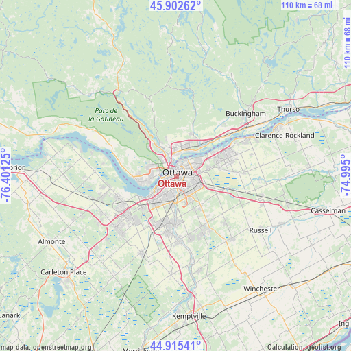
Ottawa GPS coordinates[2]
45° 24' 40.212" North, 75° 41' 53.232" West
| Map corner | latitude | longitude |
|---|---|---|
| Upper-left | 45.90262°, | -76.40125° |
| Center: | 45.41117°, | -75.69812° |
| Lower-right: | 44.91541°, | -74.995° |
| Map W x H: | 109.8×109.8 km | = 68.2×68.2mi |
| max Lat: | 73.03752° ⇑77.9% North |
| Ottawa: | 45.41117° |
| min Lat: | ⇓22.1% South 42.05009° |
| min Long | Ottawa | max Long |
| -139.43328° | -75.69812° | -52.70931° |
| W 55.9%⇐ | ⇒44.1% E |
Elevation
Elevation of Ottawa is 71 m = 233 ft, and this is 183.4 m = 602 ft below average elevation for this country.
| Max E: |
1518 m = 4980 ft | 66.1% |
| Avg. | 254.4 m = 835 ft | |
| Ottawa | 71 m = 233 ft | |
Min E: |
-2 m = -7 ft | 33.9% |
See also: Ottawa elevation on elevation.city.
Geographical zone
Ottawa is located in North temperate zone (between Tropic of Cancer and the Arctic Circle). Distance of this North polar circle is 2351.9 km =1461.4 mi to North.| Distance of | km | miles | from Ottawa |
|---|---|---|---|
| North Pole | 4957.8 | 3080.6 | to North |
| Arctic Circle | 2351.9 | 1461.4 | to North |
| Tropic Cancer | 2443.3 | 1518.2 | to South |
| Equator | 5049.2 | 3137.4 | to South |


Nearby cities:
15 places around Ottawa: (largest is in red/bold)
• Bells Corners
14.8 km =9.2 mi,  224°
224°
• Buckingham
29 km =18 mi,  48°
48°
• Cantley
18.5 km =11.5 mi,  339°
339°
• Fallingbrook
18.2 km =11.3 mi,  66°
66°
• Gatineau
7.4 km =4.6 mi,  357°
357°
• Kanata
21 km =13 mi,  234°
234°
• Metcalfe
26.8 km =16.7 mi,  137°
137°
• Nepean
7.3 km =4.5 mi,  206°
206°
• Osgoode
30.2 km =18.8 mi,  164°
164°
• Queenswood Heights
16.4 km =10.2 mi, 66°
• Richmond
27.4 km =17 mi,  202°
202°
• Saint-Alexandre
10.7 km =6.6 mi, 337°
• Val-des-Monts
26.7 km =16.6 mi,  5°
5°
• Vanier
4.1 km =2.5 mi,  38°
38°
• le Plateau
6.9 km =4.3 mi,  292°
292°
Sources, notices
• [Note1] Compared only with cities in Canada existing in our database
• [Src1] Map data: © OpenStreetMap contributors (CC-BY-SA)
• [Src2] Other city data from geonames.org with taken over terms of usage.
• [Src3] Geographical zone / Annual Mean Temperature by Robert A. Rohde @ Wikipedia
