le Plateau geodata
le Plateau (Quebec) is a populated place; located in Canada in America/Toronto (GMT-4) time zone. With population of 15,000 people, there are 242 cities with bigger population in this country. Compared to other cities in Canada, 76.9% of cities are located further ↑North; 55.6% of cities are located further ←West and 62.5% of cities have higher elevation than le Plateau. Note1


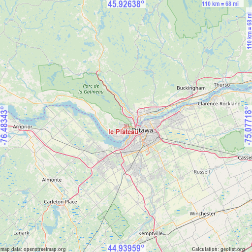
le Plateau GPS coordinates[2]
45° 26' 6.504" North, 75° 46' 49.08" West
| Map corner | latitude | longitude |
|---|---|---|
| Upper-left | 45.92638°, | -76.48343° |
| Center: | 45.43514°, | -75.7803° |
| Lower-right: | 44.93959°, | -75.07718° |
| Map W x H: | 109.7×109.7 km | = 68.2×68.2mi |
| max Lat: | 73.03752° ⇑76.9% North |
| le Plateau: | 45.43514° |
| min Lat: | ⇓23.1% South 42.05009° |
| min Long | le Plateau | max Long |
| -139.43328° | -75.7803° | -52.70931° |
| W 55.6%⇐ | ⇒44.4% E |
Elevation
Elevation of le Plateau is 89 m = 292 ft, and this is 165.4 m = 543 ft below average elevation for this country.
| Max E: |
1518 m = 4980 ft | 62.5% |
| Avg. | 254.4 m = 835 ft | |
| le Plateau | 89 m = 292 ft | |
Min E: |
-2 m = -7 ft | 37.5% |
See also: Canada elevation on elevation.city.
Geographical zone
le Plateau is located in North temperate zone (between Tropic of Cancer and the Arctic Circle). Distance of this North polar circle is 2349.3 km =1459.8 mi to North.| Distance of | km | miles | from le Plateau |
|---|---|---|---|
| North Pole | 4955.1 | 3079 | to North |
| Arctic Circle | 2349.3 | 1459.8 | to North |
| Tropic Cancer | 2446 | 1519.9 | to South |
| Equator | 5051.9 | 3139.1 | to South |


Nearby cities:
15 places around le Plateau: (largest is in red/bold)
• Bells Corners
13.8 km =8.6 mi,  196°
196°
• Buckingham
32.6 km =20.3 mi,  59°
59°
• Cantley
14.6 km =9.1 mi,  359°
359°
• Constance Bay
24.7 km =15.3 mi,  287°
287°
• Fallingbrook
23.5 km =14.6 mi,  78°
78°
• Gatineau
7.7 km =4.8 mi,  52°
52°
• Kanata
18.4 km =11.4 mi,  215°
215°
• Nepean
9.8 km =6.1 mi,  161°
161°
• Ottawa
6.9 km =4.3 mi,  112°
112°
• Queenswood Heights
21.8 km =13.5 mi, 79°
• Richmond
28.3 km =17.6 mi,  188°
188°
• Saint-Alexandre
7.6 km =4.7 mi,  18°
18°
• Val-des-Monts
25.5 km =15.8 mi, 20°
• Vanier
9 km =5.6 mi,  86°
86°
• Wakefield
26.1 km =16.2 mi,  351°
351°
Sources, notices
• [Note1] Compared only with cities in Canada existing in our database
• [Src1] Map data: © OpenStreetMap contributors (CC-BY-SA)
• [Src2] Other city data from geonames.org with taken over terms of usage.
• [Src3] Geographical zone / Annual Mean Temperature by Robert A. Rohde @ Wikipedia
