Richmond geodata
Richmond (Ontario) is a populated place; located in Canada in America/Toronto (GMT-4) time zone. With population of 4,055 people, there are 530 cities with bigger population in this country. Compared to other cities in Canada, 82.6% of cities are located further ↑North; 55.2% of cities are located further ←West and 62.1% of cities have higher elevation than Richmond. Note1


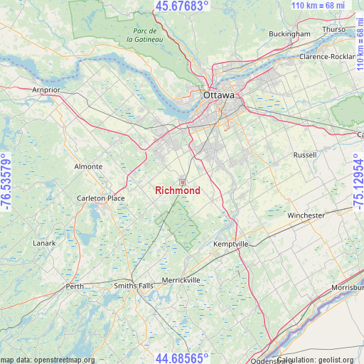
Richmond GPS coordinates[2]
45° 11' 0.24" North, 75° 49' 57.576" West
| Map corner | latitude | longitude |
|---|---|---|
| Upper-left | 45.67683°, | -76.53579° |
| Center: | 45.1834°, | -75.83266° |
| Lower-right: | 44.68565°, | -75.12954° |
| Map W x H: | 110.2×110.2 km | = 68.5×68.5mi |
| max Lat: | 73.03752° ⇑82.6% North |
| Richmond: | 45.1834° |
| min Lat: | ⇓17.4% South 42.05009° |
| min Long | Richmond | max Long |
| -139.43328° | -75.83266° | -52.70931° |
| W 55.2%⇐ | ⇒44.8% E |
Elevation
Elevation of Richmond is 90 m = 295 ft, and this is 164.4 m = 539 ft below average elevation for this country.
| Max E: |
1518 m = 4980 ft | 62.1% |
| Avg. | 254.4 m = 835 ft | |
| Richmond | 90 m = 295 ft | |
Min E: |
-2 m = -7 ft | 37.9% |
See also: Canada elevation on elevation.city.
Geographical zone
Richmond is located in North temperate zone (between Tropic of Cancer and the Arctic Circle). Distance of this North polar circle is 2377.3 km =1477.2 mi to North.| Distance of | km | miles | from Richmond |
|---|---|---|---|
| North Pole | 4983.1 | 3096.4 | to North |
| Arctic Circle | 2377.3 | 1477.2 | to North |
| Tropic Cancer | 2418 | 1502.5 | to South |
| Equator | 5023.9 | 3121.7 | to South |


Nearby cities:
15 places around Richmond: (largest is in red/bold)
• Bells Corners
14.7 km =9.1 mi,  0°
0°
• Carleton Place
25.4 km =15.8 mi,  257°
257°
• Constance Bay
40.3 km =25 mi,  330°
330°
• Gatineau
34.2 km =21.3 mi,  17°
17°
• Kanata
14.5 km =9 mi, 333°
• Metcalfe
29.3 km =18.2 mi,  79°
79°
• Nepean
20.1 km =12.5 mi, 21°
• Osgoode
18.8 km =11.7 mi,  101°
101°
• Ottawa
27.4 km =17 mi, 22°
• Russell
37.3 km =23.2 mi, 78°
• Saint-Alexandre
35.8 km =22.2 mi,  10°
10°
• Smiths Falls
34.4 km =21.4 mi,  205°
205°
• Vanier
31.4 km =19.5 mi, 24°
• Winchester
39.5 km =24.5 mi,  106°
106°
• le Plateau
28.3 km =17.6 mi, 8°
Sources, notices
• [Note1] Compared only with cities in Canada existing in our database
• [Src1] Map data: © OpenStreetMap contributors (CC-BY-SA)
• [Src2] Other city data from geonames.org with taken over terms of usage.
• [Src3] Geographical zone / Annual Mean Temperature by Robert A. Rohde @ Wikipedia
