Steinbach geodata
Steinbach (Manitoba) is a populated place; located in Canada in America/Winnipeg (GMT-5) time zone. With population of 9,607 people, there are 322 cities with bigger population in this country. Compared to other cities in Canada, 70.6% of cities are located further ↓South; 65.8% of cities are located further →East and 66% of cities have lower elevation than Steinbach. Note1


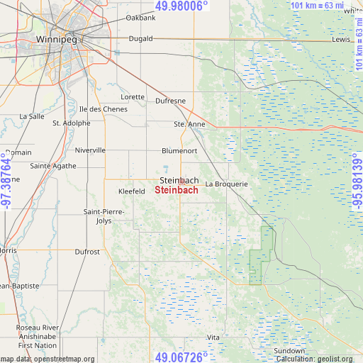
Steinbach GPS coordinates[2]
49° 31' 32.844" North, 96° 41' 4.236" West
| Map corner | latitude | longitude |
|---|---|---|
| Upper-left | 49.98006°, | -97.38764° |
| Center: | 49.52579°, | -96.68451° |
| Lower-right: | 49.06726°, | -95.98139° |
| Map W x H: | 101.5×101.5 km | = 63.1×63.1mi |
| max Lat: | 73.03752° ⇑29.4% North |
| Steinbach: | 49.52579° |
| min Lat: | ⇓70.6% South 42.05009° |
| min Long | Steinbach | max Long |
| -139.43328° | -96.68451° | -52.70931° |
| W 34.2%⇐ | ⇒65.8% E |
Elevation
Elevation of Steinbach is 263 m = 863 ft, and this is 8.6 m = 28 ft above average elevation for this country.
| Max E: |
1518 m = 4980 ft | 34% |
| Steinbach | 263 m 863 ft | |
| Avg. | 254.4 m = 835 ft | |
Min E: |
-2 m = -7 ft | 66% |
See also: Canada elevation on elevation.city.
Geographical zone
Steinbach is located in North temperate zone (between Tropic of Cancer and the Arctic Circle). Distance of this North polar circle is 1894.4 km =1177.1 mi to North.| Distance of | km | miles | from Steinbach |
|---|---|---|---|
| North Pole | 4500.3 | 2796.4 | to North |
| Arctic Circle | 1894.4 | 1177.1 | to North |
| Tropic Cancer | 2900.8 | 1802.5 | to South |
| Equator | 5506.8 | 3421.8 | to South |


Nearby cities:
15 places around Steinbach: (largest is in red/bold)
• Beausejour
60.8 km =37.8 mi,  11°
11°
• Garson
61.4 km =38.2 mi,  358°
358°
• Grunthal
18.3 km =11.4 mi,  223°
223°
• Headingley
65 km =40.4 mi,  306°
306°
• Ile des Chênes
30.1 km =18.7 mi, 313°
• La Broquerie
13.3 km =8.3 mi,  94°
94°
• Landmark
19 km =11.8 mi,  328°
328°
• Lorette
27.3 km =17 mi, 330°
• Morris
52.8 km =32.8 mi,  248°
248°
• Niverville
27.3 km =17 mi,  288°
288°
• Selkirk
70.2 km =43.6 mi,  348°
348°
• St. Adolphe
34.9 km =21.7 mi,  298°
298°
• St. Jean Baptiste
55.6 km =34.5 mi,  238°
238°
• Tyndall
62 km =38.5 mi,  1°
1°
• Winnipeg
51.9 km =32.2 mi,  320°
320°
Sources, notices
• [Note1] Compared only with cities in Canada existing in our database
• [Src1] Map data: © OpenStreetMap contributors (CC-BY-SA)
• [Src2] Other city data from geonames.org with taken over terms of usage.
• [Src3] Geographical zone / Annual Mean Temperature by Robert A. Rohde @ Wikipedia
