Grunthal geodata
Grunthal (Manitoba) is a populated place; located in Canada in America/Winnipeg (GMT-5) time zone. With population of 1,680 people, there are 816 cities with bigger population in this country. Compared to other cities in Canada, 69.3% of cities are located further ↓South; 66.1% of cities are located further →East and 66.2% of cities have lower elevation than Grunthal. Note1


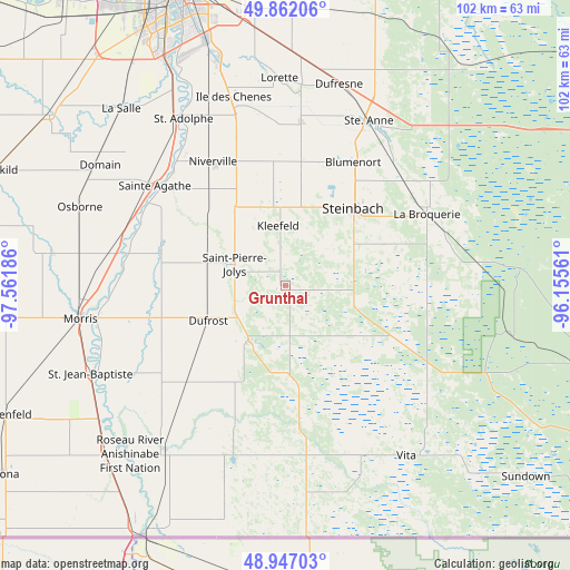
Grunthal GPS coordinates[2]
49° 24' 24.048" North, 96° 51' 31.428" West
| Map corner | latitude | longitude |
|---|---|---|
| Upper-left | 49.86206°, | -97.56186° |
| Center: | 49.40668°, | -96.85873° |
| Lower-right: | 48.94703°, | -96.15561° |
| Map W x H: | 101.7×101.7 km | = 63.2×63.2mi |
| max Lat: | 73.03752° ⇑30.7% North |
| Grunthal: | 49.40668° |
| min Lat: | ⇓69.3% South 42.05009° |
| min Long | Grunthal | max Long |
| -139.43328° | -96.85873° | -52.70931° |
| W 33.9%⇐ | ⇒66.1% E |
Elevation
Elevation of Grunthal is 266 m = 873 ft, and this is 11.6 m = 38 ft above average elevation for this country.
| Max E: |
1518 m = 4980 ft | 33.8% |
| Grunthal | 266 m 873 ft | |
| Avg. | 254.4 m = 835 ft | |
Min E: |
-2 m = -7 ft | 66.2% |
See also: Canada elevation on elevation.city.
Geographical zone
Grunthal is located in North temperate zone (between Tropic of Cancer and the Arctic Circle). Distance of this North polar circle is 1907.7 km =1185.4 mi to North.| Distance of | km | miles | from Grunthal |
|---|---|---|---|
| North Pole | 4513.6 | 2804.6 | to North |
| Arctic Circle | 1907.7 | 1185.4 | to North |
| Tropic Cancer | 2887.6 | 1794.3 | to South |
| Equator | 5493.5 | 3413.5 | to South |


Nearby cities:
15 places around Grunthal: (largest is in red/bold)
• Altona
60.9 km =37.8 mi,  236°
236°
• Garson
75.4 km =46.9 mi,  8°
8°
• Headingley
65.5 km =40.7 mi,  322°
322°
• Ile des Chênes
35.1 km =21.8 mi,  344°
344°
• La Broquerie
28.7 km =17.8 mi,  64°
64°
• Landmark
29.6 km =18.4 mi, 5°
• Lorette
37 km =23 mi,  358°
358°
• Morris
37.1 km =23.1 mi,  261°
261°
• Niverville
25.8 km =16 mi,  329°
329°
• St. Adolphe
34.9 km =21.7 mi, 328°
• St. François Xavier
74.8 km =46.5 mi, 318°
• St. Jean Baptiste
38.3 km =23.8 mi,  245°
245°
• Steinbach
18.3 km =11.4 mi,  43°
43°
• Tyndall
76.5 km =47.5 mi, 10°
• Winnipeg
57 km =35.4 mi, 338°
Sources, notices
• [Note1] Compared only with cities in Canada existing in our database
• [Src1] Map data: © OpenStreetMap contributors (CC-BY-SA)
• [Src2] Other city data from geonames.org with taken over terms of usage.
• [Src3] Geographical zone / Annual Mean Temperature by Robert A. Rohde @ Wikipedia
