Aylmer geodata
Aylmer (Ontario) is a populated place; located in Canada in America/Toronto (GMT-4) time zone. With population of 7,527 people, there are 379 cities with bigger population in this country. Compared to other cities in Canada, 99% of cities are located further ↑North; 58.8% of cities are located further →East and 59.4% of cities have lower elevation than Aylmer. Note1


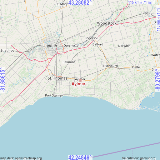
Aylmer GPS coordinates[2]
42° 46' 0.444" North, 80° 58' 58.872" West
| Map corner | latitude | longitude |
|---|---|---|
| Upper-left | 43.28082°, | -81.68615° |
| Center: | 42.76679°, | -80.98302° |
| Lower-right: | 42.24846°, | -80.2799° |
| Map W x H: | 114.8×114.8 km | = 71.3×71.3mi |
| max Lat: | 73.03752° ⇑99% North |
| Aylmer: | 42.76679° |
| min Lat: | ⇓1% South 42.05009° |
| min Long | Aylmer | max Long |
| -139.43328° | -80.98302° | -52.70931° |
| W 41.2%⇐ | ⇒58.8% E |
Elevation
Elevation of Aylmer is 229 m = 751 ft, and this is 25.4 m = 83 ft below average elevation for this country.
| Max E: |
1518 m = 4980 ft | 40.6% |
| Avg. | 254.4 m = 835 ft | |
| Aylmer | 229 m = 751 ft | |
Min E: |
-2 m = -7 ft | 59.4% |
See also: Canada elevation on elevation.city.
Geographical zone
Aylmer is located in North temperate zone (between Tropic of Cancer and the Arctic Circle). Distance of this Northern Tropic circle is 2149.3 km =1335.5 mi to South.| Distance of | km | miles | from Aylmer |
|---|---|---|---|
| North Pole | 5251.8 | 3263.3 | to North |
| Arctic Circle | 2646 | 1644.1 | to North |
| Tropic Cancer | 2149.3 | 1335.5 | to South |
| Equator | 4755.2 | 2954.7 | to South |


Nearby cities:
15 places around Aylmer: (largest is in red/bold)
• Belmont
15.3 km =9.5 mi,  327°
327°
• Burford
58.6 km =36.4 mi,  50°
50°
• Delaware
39.1 km =24.3 mi,  295°
295°
• Dorchester
25 km =15.5 mi,  344°
344°
• Ingersoll
30.7 km =19.1 mi,  15°
15°
• London
31.5 km =19.6 mi,  319°
319°
• Lucan
57.4 km =35.7 mi, 323°
• Mount Brydges
43.4 km =27 mi,  289°
289°
• Norfolk County
49.5 km =30.8 mi,  81°
81°
• Port Rowan
45.4 km =28.2 mi,  111°
111°
• Port Stanley
22.1 km =13.7 mi,  239°
239°
• Simcoe
56.2 km =34.9 mi, 82°
• St. Thomas
16.1 km =10 mi,  272°
272°
• West Lorne
53.7 km =33.4 mi,  249°
249°
• Woodstock
45 km =28 mi, 24°
Sources, notices
• [Note1] Compared only with cities in Canada existing in our database
• [Src1] Map data: © OpenStreetMap contributors (CC-BY-SA)
• [Src2] Other city data from geonames.org with taken over terms of usage.
• [Src3] Geographical zone / Annual Mean Temperature by Robert A. Rohde @ Wikipedia
