Athabasca geodata
Athabasca (Alberta) is a populated place; located in Canada in America/Edmonton (GMT-6) time zone. With population of 2,539 people, there are 669 cities with bigger population in this country. Compared to other cities in Canada, 94.8% of cities are located further ↓South; 78.1% of cities are located further →East and 83.4% of cities have lower elevation than Athabasca. Note1


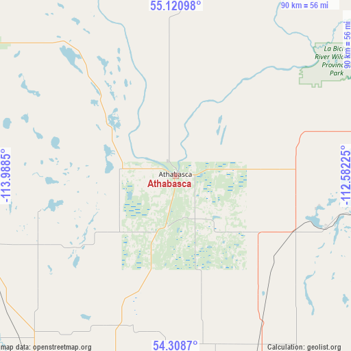
Athabasca GPS coordinates[2]
54° 43' 0.732" North, 113° 17' 7.332" West
| Map corner | latitude | longitude |
|---|---|---|
| Upper-left | 55.12098°, | -113.9885° |
| Center: | 54.71687°, | -113.28537° |
| Lower-right: | 54.3087°, | -112.58225° |
| Map W x H: | 90.3×90.3 km | = 56.1×56.1mi |
| max Lat: | 73.03752° ⇑5.2% North |
| Athabasca: | 54.71687° |
| min Lat: | ⇓94.8% South 42.05009° |
| min Long | Athabasca | max Long |
| -139.43328° | -113.28537° | -52.70931° |
| W 21.9%⇐ | ⇒78.1% E |
Elevation
Elevation of Athabasca is 534 m = 1752 ft, and this is 279.6 m = 917 ft above average elevation for this country.
| Max E: |
1518 m = 4980 ft | 16.6% |
| Athabasca | 534 m 1752 ft | |
| Avg. | 254.4 m = 835 ft | |
Min E: |
-2 m = -7 ft | 83.4% |
See also: Canada elevation on elevation.city.
Geographical zone
Athabasca is located in North temperate zone (between Tropic of Cancer and the Arctic Circle). Distance of this North polar circle is 1317.2 km =818.5 mi to North.| Distance of | km | miles | from Athabasca |
|---|---|---|---|
| North Pole | 3923.1 | 2437.7 | to North |
| Arctic Circle | 1317.2 | 818.5 | to North |
| Tropic Cancer | 3478 | 2161.1 | to South |
| Equator | 6083.9 | 3780.4 | to South |


Nearby cities:
15 places around Athabasca: (largest is in red/bold)
• Barrhead
97.1 km =60.3 mi,  228°
228°
• Bon Accord
98.6 km =61.3 mi,  185°
185°
• Edmonton
130.3 km =81 mi, 185°
• Fort Saskatchewan
111.3 km =69.2 mi,  177°
177°
• Gibbons
98.3 km =61.1 mi, 181°
• Lac La Biche
84.7 km =52.6 mi,  86°
86°
• Lamont
110.2 km =68.5 mi,  163°
163°
• Maple Ridge
135.2 km =84 mi, 182°
• Morinville
104.7 km =65.1 mi, 193°
• Sherwood Park
133.4 km =82.9 mi, 180°
• Slave Lake
113.7 km =70.6 mi,  303°
303°
• Smoky Lake
85.1 km =52.9 mi,  141°
141°
• St. Albert
122.6 km =76.2 mi, 190°
• Swan Hills
136 km =84.5 mi,  269°
269°
• Westlock
73.4 km =45.6 mi,  210°
210°
Sources, notices
• [Note1] Compared only with cities in Canada existing in our database
• [Src1] Map data: © OpenStreetMap contributors (CC-BY-SA)
• [Src2] Other city data from geonames.org with taken over terms of usage.
• [Src3] Geographical zone / Annual Mean Temperature by Robert A. Rohde @ Wikipedia
