St. Claude geodata
St. Claude (Manitoba) is a populated place; located in Canada in America/Winnipeg (GMT-5) time zone. With population of 600 people, there are 1149 cities with bigger population in this country. Compared to other cities in Canada, 71.8% of cities are located further ↓South; 67.8% of cities are located further →East and 70.5% of cities have lower elevation than St. Claude. Note1


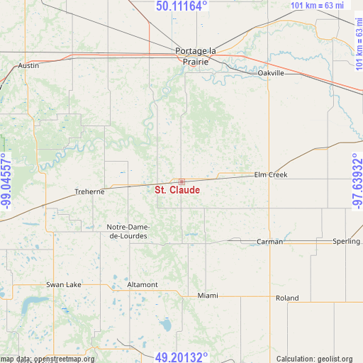
St. Claude GPS coordinates[2]
49° 39' 30.996" North, 98° 20' 32.784" West
| Map corner | latitude | longitude |
|---|---|---|
| Upper-left | 50.11164°, | -99.04557° |
| Center: | 49.65861°, | -98.34244° |
| Lower-right: | 49.20132°, | -97.63932° |
| Map W x H: | 101.2×101.2 km | = 62.9×62.9mi |
| max Lat: | 73.03752° ⇑28.2% North |
| St. Claude: | 49.65861° |
| min Lat: | ⇓71.8% South 42.05009° |
| min Long | St. Claude | max Long |
| -139.43328° | -98.34244° | -52.70931° |
| W 32.2%⇐ | ⇒67.8% E |
Elevation
Elevation of St. Claude is 308 m = 1010 ft, and this is 53.6 m = 176 ft above average elevation for this country.
| Max E: |
1518 m = 4980 ft | 29.5% |
| St. Claude | 308 m 1010 ft | |
| Avg. | 254.4 m = 835 ft | |
Min E: |
-2 m = -7 ft | 70.5% |
See also: Canada elevation on elevation.city.
Geographical zone
St. Claude is located in North temperate zone (between Tropic of Cancer and the Arctic Circle). Distance of this North polar circle is 1879.7 km =1168 mi to North.| Distance of | km | miles | from St. Claude |
|---|---|---|---|
| North Pole | 4485.5 | 2787.2 | to North |
| Arctic Circle | 1879.7 | 1168 | to North |
| Tropic Cancer | 2915.6 | 1811.7 | to South |
| Equator | 5521.5 | 3430.9 | to South |


Nearby cities:
15 places around St. Claude: (largest is in red/bold)
• Altona
83.7 km =52 mi,  137°
137°
• Carberry
76.7 km =47.7 mi,  287°
287°
• Carman
30.3 km =18.8 mi,  125°
125°
• Headingley
71.2 km =44.2 mi,  70°
70°
• Morden
54.7 km =34 mi,  161°
161°
• Morris
78.2 km =48.6 mi,  115°
115°
• Niverville
93.8 km =58.3 mi,  93°
93°
• Portage la Prairie
35.1 km =21.8 mi,  5°
5°
• St. Adolphe
88.6 km =55.1 mi, 88°
• St. François Xavier
64 km =39.8 mi,  63°
63°
• St. Jean Baptiste
84.6 km =52.6 mi, 121°
• Stonewall
89.9 km =55.9 mi,  53°
53°
• Warren
77.5 km =48.2 mi, 47°
• Winkler
60.5 km =37.6 mi,  151°
151°
• Winnipeg
89.4 km =55.6 mi, 73°
Sources, notices
• [Note1] Compared only with cities in Canada existing in our database
• [Src1] Map data: © OpenStreetMap contributors (CC-BY-SA)
• [Src2] Other city data from geonames.org with taken over terms of usage.
• [Src3] Geographical zone / Annual Mean Temperature by Robert A. Rohde @ Wikipedia
