Dorchester geodata
Dorchester (Ontario) is a populated place; located in Canada in America/Toronto (GMT-4) time zone. With population of 9,329 people, there are 330 cities with bigger population in this country. Compared to other cities in Canada, 97.6% of cities are located further ↑North; 59.3% of cities are located further →East and 65.7% of cities have lower elevation than Dorchester. Note1


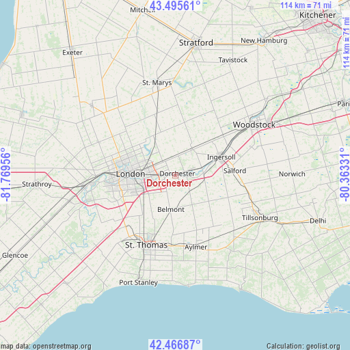
Dorchester GPS coordinates[2]
42° 59' 0.204" North, 81° 3' 59.148" West
| Map corner | latitude | longitude |
|---|---|---|
| Upper-left | 43.49561°, | -81.76956° |
| Center: | 42.98339°, | -81.06643° |
| Lower-right: | 42.46687°, | -80.36331° |
| Map W x H: | 114.4×114.4 km | = 71.1×71.1mi |
| max Lat: | 73.03752° ⇑97.6% North |
| Dorchester: | 42.98339° |
| min Lat: | ⇓2.4% South 42.05009° |
| min Long | Dorchester | max Long |
| -139.43328° | -81.06643° | -52.70931° |
| W 40.7%⇐ | ⇒59.3% E |
Elevation
Elevation of Dorchester is 260 m = 853 ft, and this is 5.6 m = 18 ft above average elevation for this country.
| Max E: |
1518 m = 4980 ft | 34.3% |
| Dorchester | 260 m 853 ft | |
| Avg. | 254.4 m = 835 ft | |
Min E: |
-2 m = -7 ft | 65.7% |
See also: Canada elevation on elevation.city.
Geographical zone
Dorchester is located in North temperate zone (between Tropic of Cancer and the Arctic Circle). Distance of this Northern Tropic circle is 2173.4 km =1350.5 mi to South.| Distance of | km | miles | from Dorchester |
|---|---|---|---|
| North Pole | 5227.8 | 3248.4 | to North |
| Arctic Circle | 2621.9 | 1629.2 | to North |
| Tropic Cancer | 2173.4 | 1350.5 | to South |
| Equator | 4779.3 | 2969.7 | to South |


Nearby cities:
15 places around Dorchester: (largest is in red/bold)
• Aylmer
25 km =15.5 mi,  164°
164°
• Belmont
11.2 km =7 mi,  186°
186°
• Delaware
29.4 km =18.3 mi,  255°
255°
• Ingersoll
15.9 km =9.9 mi,  69°
69°
• London
13.6 km =8.5 mi,  270°
270°
• Lucan
35 km =21.7 mi,  309°
309°
• Mount Brydges
35.2 km =21.9 mi,  254°
254°
• New Hamburg
53.5 km =33.2 mi,  33°
33°
• Plattsville
50.7 km =31.5 mi,  46°
46°
• Port Stanley
37.3 km =23.2 mi,  199°
199°
• South Huron
52 km =32.3 mi,  315°
315°
• St. Thomas
25.1 km =15.6 mi, 201°
• Stratford
43.7 km =27.2 mi,  12°
12°
• Tavistock
41.6 km =25.8 mi, 27°
• Woodstock
30.7 km =19.1 mi,  57°
57°
Sources, notices
• [Note1] Compared only with cities in Canada existing in our database
• [Src1] Map data: © OpenStreetMap contributors (CC-BY-SA)
• [Src2] Other city data from geonames.org with taken over terms of usage.
• [Src3] Geographical zone / Annual Mean Temperature by Robert A. Rohde @ Wikipedia
