Sydney geodata
Sydney (Nova Scotia) is a populated place; located in Canada in America/Glace_Bay (GMT-3) time zone. With population of 105,968 people, there are 51 cities with bigger population in this country. Compared to other cities in Canada, 60.4% of cities are located further ↑North; 96.7% of cities are located further ←West and 96.5% of cities have higher elevation than Sydney. Note1


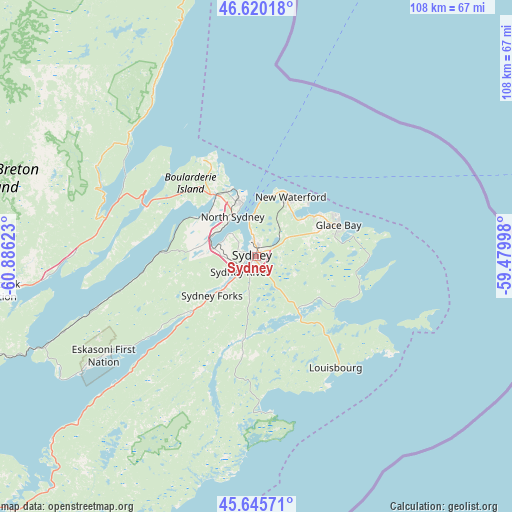
Sydney GPS coordinates[2]
46° 8' 6.36" North, 60° 10' 59.16" West
| Map corner | latitude | longitude |
|---|---|---|
| Upper-left | 46.62018°, | -60.88623° |
| Center: | 46.1351°, | -60.1831° |
| Lower-right: | 45.64571°, | -59.47998° |
| Map W x H: | 108.4×108.4 km | = 67.4×67.4mi |
| max Lat: | 73.03752° ⇑60.4% North |
| Sydney: | 46.1351° |
| min Lat: | ⇓39.6% South 42.05009° |
| min Long | Sydney | max Long |
| -139.43328° | -60.1831° | -52.70931° |
| W 96.7%⇐ | ⇒3.3% E |
Elevation
Elevation of Sydney is 6 m = 20 ft, and this is 248.4 m = 815 ft below average elevation for this country.
| Max E: |
1518 m = 4980 ft | 96.5% |
| Avg. | 254.4 m = 835 ft | |
| Sydney | 6 m = 20 ft | |
Min E: |
-2 m = -7 ft | 3.5% |
See also: Sydney elevation on elevation.city.
Geographical zone
Sydney is located in North temperate zone (between Tropic of Cancer and the Arctic Circle). Distance of this North polar circle is 2271.4 km =1411.4 mi to North.| Distance of | km | miles | from Sydney |
|---|---|---|---|
| North Pole | 4877.3 | 3030.6 | to North |
| Arctic Circle | 2271.4 | 1411.4 | to North |
| Tropic Cancer | 2523.8 | 1568.2 | to South |
| Equator | 5129.7 | 3187.4 | to South |


Nearby cities:
15 places around Sydney: (largest is in red/bold)
• Antigonish
151.9 km =94.4 mi,  247°
247°
• Belfast
208.1 km =129.3 mi,  268°
268°
• Channel-Port aux Basques
178.5 km =110.9 mi,  26°
26°
• Charlottetown
227.4 km =141.3 mi, 272°
• Cornwall
233.9 km =145.3 mi, 272°
• Eskasoni 3
39.5 km =24.5 mi,  237°
237°
• Glace Bay
18.7 km =11.6 mi,  68°
68°
• Middleton
236.3 km =146.8 mi,  258°
258°
• Montague
189.9 km =118 mi, 271°
• New Glasgow
200.5 km =124.6 mi, 252°
• Pictou
201.9 km =125.5 mi, 255°
• Port Hawkesbury
107 km =66.5 mi, 237°
• Princeville
95.5 km =59.3 mi, 244°
• Souris
160.6 km =99.8 mi,  278°
278°
• Sydney Mines
11.6 km =7.2 mi,  346°
346°
Sources, notices
• [Note1] Compared only with cities in Canada existing in our database
• [Src1] Map data: © OpenStreetMap contributors (CC-BY-SA)
• [Src2] Other city data from geonames.org with taken over terms of usage.
• [Src3] Geographical zone / Annual Mean Temperature by Robert A. Rohde @ Wikipedia
