Belfast geodata
Belfast (Prince Edward Island) is a populated locality; located in Canada in America/Halifax (GMT-3) time zone. With population of 1,839 people, there are 783 cities with bigger population in this country. Compared to other cities in Canada, 61.2% of cities are located further ↑North; 95.7% of cities are located further ←West and 90.3% of cities have higher elevation than Belfast. Note1


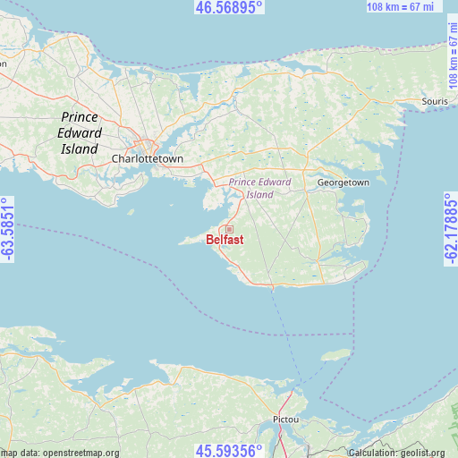
Belfast GPS coordinates[2]
46° 5' 0.276" North, 62° 52' 55.092" West
| Map corner | latitude | longitude |
|---|---|---|
| Upper-left | 46.56895°, | -63.5851° |
| Center: | 46.08341°, | -62.88197° |
| Lower-right: | 45.59356°, | -62.17885° |
| Map W x H: | 108.5×108.5 km | = 67.4×67.4mi |
| max Lat: | 73.03752° ⇑61.2% North |
| Belfast: | 46.08341° |
| min Lat: | ⇓38.8% South 42.05009° |
| min Long | Belfast | max Long |
| -139.43328° | -62.88197° | -52.70931° |
| W 95.7%⇐ | ⇒4.3% E |
Elevation
Elevation of Belfast is 14 m = 46 ft, and this is 240.4 m = 789 ft below average elevation for this country.
| Max E: |
1518 m = 4980 ft | 90.3% |
| Avg. | 254.4 m = 835 ft | |
| Belfast | 14 m = 46 ft | |
Min E: |
-2 m = -7 ft | 9.7% |
See also: Canada elevation on elevation.city.
Geographical zone
Belfast is located in North temperate zone (between Tropic of Cancer and the Arctic Circle). Distance of this North polar circle is 2277.2 km =1415 mi to North.| Distance of | km | miles | from Belfast |
|---|---|---|---|
| North Pole | 4883.1 | 3034.2 | to North |
| Arctic Circle | 2277.2 | 1415 | to North |
| Tropic Cancer | 2518.1 | 1564.7 | to South |
| Equator | 5124 | 3183.9 | to South |


Nearby cities:
15 places around Belfast: (largest is in red/bold)
• Amherst
105.5 km =65.6 mi,  254°
254°
• Antigonish
85.9 km =53.4 mi,  127°
127°
• Charlottetown
26 km =16.2 mi,  311°
311°
• Cornwall
30.4 km =18.9 mi,  301°
301°
• Kensington
70.6 km =43.9 mi, 303°
• Middleton
46.8 km =29.1 mi,  209°
209°
• Montague
20.2 km =12.6 mi,  62°
62°
• New Glasgow
58.5 km =36.4 mi,  161°
161°
• Oxford
85.5 km =53.1 mi,  242°
242°
• Pictou
46.9 km =29.1 mi, 163°
• Point de Bute
107 km =66.5 mi,  259°
259°
• Souris
57 km =35.4 mi, 58°
• Springhill
102.4 km =63.6 mi, 241°
• Summerside
77.8 km =48.3 mi, 296°
• Truro
85.1 km =52.9 mi,  200°
200°
Sources, notices
• [Note1] Compared only with cities in Canada existing in our database
• [Src1] Map data: © OpenStreetMap contributors (CC-BY-SA)
• [Src2] Other city data from geonames.org with taken over terms of usage.
• [Src3] Geographical zone / Annual Mean Temperature by Robert A. Rohde @ Wikipedia
