Montague geodata
Montague (Prince Edward Island) is a populated place; located in Canada in America/Halifax (GMT-3) time zone. With population of 1,834 people, there are 785 cities with bigger population in this country. Compared to other cities in Canada, 59.9% of cities are located further ↑North; 95.9% of cities are located further ←West and 92.7% of cities have higher elevation than Montague. Note1


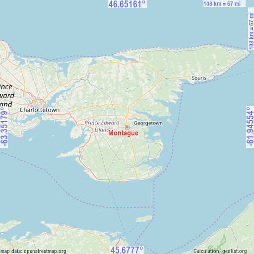
Montague GPS coordinates[2]
46° 10' 0.516" North, 62° 38' 55.176" West
| Map corner | latitude | longitude |
|---|---|---|
| Upper-left | 46.65161°, | -63.35179° |
| Center: | 46.16681°, | -62.64866° |
| Lower-right: | 45.6777°, | -61.94554° |
| Map W x H: | 108.3×108.3 km | = 67.3×67.3mi |
| max Lat: | 73.03752° ⇑59.9% North |
| Montague: | 46.16681° |
| min Lat: | ⇓40.1% South 42.05009° |
| min Long | Montague | max Long |
| -139.43328° | -62.64866° | -52.70931° |
| W 95.9%⇐ | ⇒4.1% E |
Elevation
Elevation of Montague is 11 m = 36 ft, and this is 243.4 m = 799 ft below average elevation for this country.
| Max E: |
1518 m = 4980 ft | 92.7% |
| Avg. | 254.4 m = 835 ft | |
| Montague | 11 m = 36 ft | |
Min E: |
-2 m = -7 ft | 7.3% |
See also: Canada elevation on elevation.city.
Geographical zone
Montague is located in North temperate zone (between Tropic of Cancer and the Arctic Circle). Distance of this North polar circle is 2267.9 km =1409.2 mi to North.| Distance of | km | miles | from Montague |
|---|---|---|---|
| North Pole | 4873.8 | 3028.4 | to North |
| Arctic Circle | 2267.9 | 1409.2 | to North |
| Tropic Cancer | 2527.3 | 1570.4 | to South |
| Equator | 5133.3 | 3189.7 | to South |


Nearby cities:
15 places around Montague: (largest is in red/bold)
• Antigonish
79.2 km =49.2 mi,  140°
140°
• Belfast
20.2 km =12.6 mi,  242°
242°
• Charlottetown
38.2 km =23.7 mi,  282°
282°
• Cornwall
44.3 km =27.5 mi, 278°
• Kensington
82.3 km =51.1 mi,  291°
291°
• Middleton
64.7 km =40.2 mi,  219°
219°
• New Glasgow
64.9 km =40.3 mi,  179°
179°
• Oxford
105.7 km =65.7 mi, 242°
• Pictou
54.5 km =33.9 mi, 184°
• Port Hawkesbury
117.7 km =73.1 mi,  121°
121°
• Princeville
113.4 km =70.5 mi,  113°
113°
• Souris
36.9 km =22.9 mi,  56°
56°
• Springhill
122.6 km =76.2 mi, 242°
• Summerside
91.2 km =56.7 mi, 286°
• Truro
101 km =62.8 mi,  208°
208°
Sources, notices
• [Note1] Compared only with cities in Canada existing in our database
• [Src1] Map data: © OpenStreetMap contributors (CC-BY-SA)
• [Src2] Other city data from geonames.org with taken over terms of usage.
• [Src3] Geographical zone / Annual Mean Temperature by Robert A. Rohde @ Wikipedia
