Charlottetown geodata
Charlottetown (Prince Edward Island) is a seat of a first-order administrative division; located in Canada in America/Halifax (GMT-3) time zone. With population of 42,402 people, there are 115 cities with bigger population in this country. Compared to other cities in Canada, 58.4% of cities are located further ↑North; 95.6% of cities are located further ←West and 97.3% of cities have higher elevation than Charlottetown. Note1


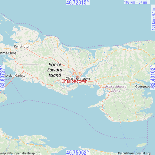
Charlottetown GPS coordinates[2]
46° 14' 20.364" North, 63° 8' 2.904" West
| Map corner | latitude | longitude |
|---|---|---|
| Upper-left | 46.72315°, | -63.83727° |
| Center: | 46.23899°, | -63.13414° |
| Lower-right: | 45.75052°, | -62.43102° |
| Map W x H: | 108.1×108.1 km | = 67.2×67.2mi |
| max Lat: | 73.03752° ⇑58.4% North |
| Charlottetown: | 46.23899° |
| min Lat: | ⇓41.6% South 42.05009° |
| min Long | Charlottetown | max Long |
| -139.43328° | -63.13414° | -52.70931° |
| W 95.6%⇐ | ⇒4.4% E |
Elevation
Elevation of Charlottetown is 5 m = 16 ft, and this is 249.4 m = 818 ft below average elevation for this country.
| Max E: |
1518 m = 4980 ft | 97.3% |
| Avg. | 254.4 m = 835 ft | |
| Charlottetown | 5 m = 16 ft | |
Min E: |
-2 m = -7 ft | 2.7% |
See also: Charlottetown elevation on elevation.city.
Geographical zone
Charlottetown is located in North temperate zone (between Tropic of Cancer and the Arctic Circle). Distance of this North polar circle is 2259.9 km =1404.2 mi to North.| Distance of | km | miles | from Charlottetown |
|---|---|---|---|
| North Pole | 4865.8 | 3023.5 | to North |
| Arctic Circle | 2259.9 | 1404.2 | to North |
| Tropic Cancer | 2535.4 | 1575.4 | to South |
| Equator | 5141.3 | 3194.7 | to South |


Nearby cities:
15 places around Charlottetown: (largest is in red/bold)
• Alberton
95.9 km =59.6 mi,  312°
312°
• Amherst
93.7 km =58.2 mi,  241°
241°
• Belfast
26 km =16.2 mi,  131°
131°
• Cornwall
6.6 km =4.1 mi,  257°
257°
• Kensington
45 km =28 mi,  298°
298°
• Middleton
58.2 km =36.2 mi,  183°
183°
• Montague
38.2 km =23.7 mi,  102°
102°
• New Glasgow
82 km =51 mi,  152°
152°
• Oxford
79.7 km =49.5 mi,  225°
225°
• Pictou
70.4 km =43.7 mi, 152°
• Point de Bute
93.4 km =58 mi,  246°
246°
• Souris
69.1 km =42.9 mi,  79°
79°
• Springhill
96.4 km =59.9 mi, 227°
• Summerside
53.1 km =33 mi,  289°
289°
• Truro
97.5 km =60.6 mi,  185°
185°
Sources, notices
• [Note1] Compared only with cities in Canada existing in our database
• [Src1] Map data: © OpenStreetMap contributors (CC-BY-SA)
• [Src2] Other city data from geonames.org with taken over terms of usage.
• [Src3] Geographical zone / Annual Mean Temperature by Robert A. Rohde @ Wikipedia
